IMAGES TAKEN NEAR TO
Mythop Road, BLACKPOOL, FY4 4XA
Introduction
This page details the photographs taken nearby to Mythop Road, FY4 4XA by members of the Geograph project.
The Geograph project started in 2005 with the aim of publishing, organising and preserving representative images for every square kilometre of Great Britain, Ireland and the Isle of Man.

There are currently over 7.5m images from over14,400 individuals and you can help contribute to the project by visiting https://www.geograph.org.uk
Image Map (Loading...)


Getting Data...Please wait
Leaflet Map data © OpenStreetMap
Images are licensed for reuse under creativecommons.org/licenses/by-sa/2.0
Notes
- Clicking on the map will re-center to the selected point.
- The higher the marker number, the further away the image location is from the centre of the postcode.
Image Listing (12 Images Found)
Images are licensed for reuse under creativecommons.org/licenses/by-sa/2.0
Image
Details
Distance
1
Mythop Village
Tiny settlement east of Blackpool.
Image: © Stephen Sweeney
Taken: 1 Jul 2009
0.04 miles
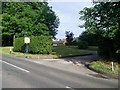
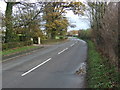
3
Road junction
of Chain Lane and Mythop Road
Image: © Alexander P Kapp
Taken: 11 Jun 2007
0.10 miles
4
Warehouse in Mythop Village
Just off Mythop Road.
Image: © Stephen Sweeney
Taken: 1 Jul 2009
0.13 miles
5

Woodland beyond Mythop Road
From Chain Lane.
Image: © Stephen Sweeney
Taken: 1 Jul 2009
0.14 miles

8
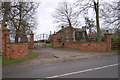
Mythop Grange
Mythop Grange is now part of a modern housing complex near Staining.
Image: © Keith Wright
Taken: 22 Dec 2005
0.17 miles
9
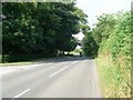
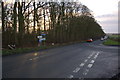
Mythop Road
Heading east, away from the village.
Image: © Stephen Sweeney
Taken: 1 Jul 2009
0.17 miles
10
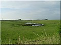
Small pools of water by Mythop Road
Visible on the 1:25,000 OS map.
Image: © Stephen Sweeney
Taken: 1 Jul 2009
0.18 miles