IMAGES TAKEN NEAR TO
Cherry Tree Road, BLACKPOOL, FY4 4TH
Introduction
This page details the photographs taken nearby to Cherry Tree Road, FY4 4TH by members of the Geograph project.
The Geograph project started in 2005 with the aim of publishing, organising and preserving representative images for every square kilometre of Great Britain, Ireland and the Isle of Man.

There are currently over 7.5m images from over14,400 individuals and you can help contribute to the project by visiting https://www.geograph.org.uk
Image Map
Images are licensed for reuse under creativecommons.org/licenses/by-sa/2.0
Notes
- Clicking on the map will re-center to the selected point.
- The higher the marker number, the further away the image location is from the centre of the postcode.
Image Listing (10 Images Found)
Images are licensed for reuse under creativecommons.org/licenses/by-sa/2.0
Image
Details
Distance
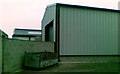
2

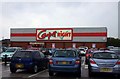
The ASDA superstore on Cherry Tree Road
Image: © Steve Daniels
Taken: 16 Sep 2011
0.05 miles


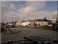
8
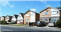
Cherry Tree Gardens
Sheltered housing complex on the site of a former pub and amusement gardens.
Image: © John Illingworth
Taken: 13 Oct 2005
0.21 miles
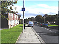
9
Vicarage Lane, Blackpool
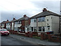
Downbeat urban semi-detached housing on Vicarage Lane in the Marton area of Blackpool, Lancashire, England - as seen from the carpark of a B&M Bargains store.
Image: © Steven Haslington
Taken: 13 Oct 2011
0.22 miles