IMAGES TAKEN NEAR TO
Loftos Avenue, BLACKPOOL, FY4 3HA
Introduction
This page details the photographs taken nearby to Loftos Avenue, FY4 3HA by members of the Geograph project.
The Geograph project started in 2005 with the aim of publishing, organising and preserving representative images for every square kilometre of Great Britain, Ireland and the Isle of Man.

There are currently over 7.5m images from over14,400 individuals and you can help contribute to the project by visiting https://www.geograph.org.uk
Image Map
Images are licensed for reuse under creativecommons.org/licenses/by-sa/2.0
Notes
- Clicking on the map will re-center to the selected point.
- The higher the marker number, the further away the image location is from the centre of the postcode.
Image Listing (14 Images Found)
Images are licensed for reuse under creativecommons.org/licenses/by-sa/2.0
Image
Details
Distance
4
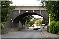
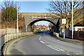
Bridge over Hawes Side Lane
Yeadon Way crosses Hawes Side Lane.
Image: © Steve Daniels
Taken: 20 Sep 2013
0.16 miles
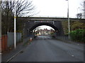
5
Yeadon Way Bridge, Hawes Side
Bridge taking Yeadon Way over Hawes Side Lane (B5261)
Image: © David Dixon
Taken: 24 Dec 2014
0.16 miles
6
Yeadon Way
Where it crosses Hawes Side Lane.
Image: © Peter Bond
Taken: 4 Feb 2011
0.17 miles
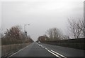
7
Hawes Side Lane (B5261)
Carries Yeadon Way.
Image: © JThomas
Taken: 15 Nov 2014
0.17 miles
9
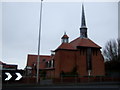
St Christopher & St Nicholas Parish Church
On Hawes Side Lane.
Image: © JThomas
Taken: 15 Nov 2014
0.17 miles
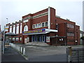
10
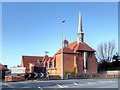
St Christopher's Church, Hawes Side
Anglican parish church dating from 1947.
Image: © David Dixon
Taken: 24 Dec 2014
0.17 miles