IMAGES TAKEN NEAR TO
Links Point, Amy Johnson Way, BLACKPOOL, FY4 2RS
Introduction
This page details the photographs taken nearby to Links Point, Amy Johnson Way, FY4 2RS by members of the Geograph project.
The Geograph project started in 2005 with the aim of publishing, organising and preserving representative images for every square kilometre of Great Britain, Ireland and the Isle of Man.

There are currently over 7.5m images from over14,400 individuals and you can help contribute to the project by visiting https://www.geograph.org.uk
Image Map (Loading...)


Getting Data...Please wait
Leaflet Map data © OpenStreetMap
Images are licensed for reuse under creativecommons.org/licenses/by-sa/2.0
Notes
- Clicking on the map will re-center to the selected point.
- The higher the marker number, the further away the image location is from the centre of the postcode.
Image Listing (7 Images Found)
Images are licensed for reuse under creativecommons.org/licenses/by-sa/2.0
Image
Details
Distance
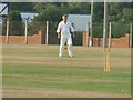
1
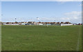
Playing Fields
The football field at Marton fold playing fields.
Image: © Roger May
Taken: 8 Aug 2005
0.06 miles

4
Amy Johnson Way, Blackpool Business park
Road through the industrial estate.
Image: © David Dixon
Taken: 12 Aug 2012
0.20 miles
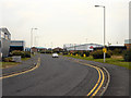
6
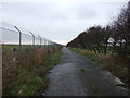
Perimeter, former Blackpool International Airport
Access road beside the former airport perimeter fence.
Image: © JThomas
Taken: 15 Nov 2014
0.25 miles