IMAGES TAKEN NEAR TO
Oak Grove, BLACKPOOL, FY4 2JR
Introduction
This page details the photographs taken nearby to Oak Grove, FY4 2JR by members of the Geograph project.
The Geograph project started in 2005 with the aim of publishing, organising and preserving representative images for every square kilometre of Great Britain, Ireland and the Isle of Man.

There are currently over 7.5m images from over14,400 individuals and you can help contribute to the project by visiting https://www.geograph.org.uk
Image Map (Loading...)


Getting Data...Please wait
Leaflet Map data © OpenStreetMap
Images are licensed for reuse under creativecommons.org/licenses/by-sa/2.0
Notes
- Clicking on the map will re-center to the selected point.
- The higher the marker number, the further away the image location is from the centre of the postcode.
Image Listing (2 Images Found)
Images are licensed for reuse under creativecommons.org/licenses/by-sa/2.0
Image
Details
Distance
1
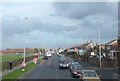
Highfield Road
Running northeasterly from St Anne's Road, alongside playing fields.
Image: © Barbara Carr
Taken: 25 Oct 2013
0.18 miles
2
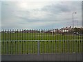
Harrowside Playing Fields
On the corner of St Annes Road and Highfield Road.
Image: © Gerald England
Taken: 1 May 2010
0.20 miles