IMAGES TAKEN NEAR TO
St. Annes Road, BLACKPOOL, FY4 2BD
Introduction
This page details the photographs taken nearby to St. Annes Road, FY4 2BD by members of the Geograph project.
The Geograph project started in 2005 with the aim of publishing, organising and preserving representative images for every square kilometre of Great Britain, Ireland and the Isle of Man.

There are currently over 7.5m images from over14,400 individuals and you can help contribute to the project by visiting https://www.geograph.org.uk
Image Map (Loading...)


Getting Data...Please wait
Leaflet Map data © OpenStreetMap
Images are licensed for reuse under creativecommons.org/licenses/by-sa/2.0
Notes
- Clicking on the map will re-center to the selected point.
- The higher the marker number, the further away the image location is from the centre of the postcode.
Image Listing (25 Images Found)
Images are licensed for reuse under creativecommons.org/licenses/by-sa/2.0
Image
Details
Distance
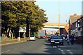
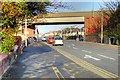
1
St Anne's Road
The bridge carries Yeadon Way over St Anne's Road.
Image: © Barbara Carr
Taken: 25 Oct 2013
0.05 miles
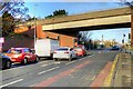
2
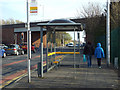
Bus stop, St Anne's Road, South Shore, Blackpool
Looking south. The bridge carries Yeadon Way into the town centre – a former rail route. See Image
Thanks to Gerald England for information and links.
Image: © Robin Stott
Taken: 20 Apr 2015
0.06 miles
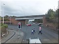
4

Palatine Library and Learning Centre, St Anne's Road
Image: © David Dixon
Taken: 24 Dec 2014
0.08 miles
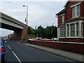
5
Yeadon Way Bridge, St Anne's Road, Blackpool
Image: © David Dixon
Taken: 24 Dec 2014
0.08 miles
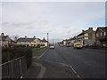
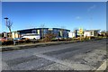
8
Looking east on Watson Road
To the junction with St Anne's Road, beneath the causeway carrying Yeadon Way.
Image: © Stephen Sweeney
Taken: 30 Jun 2009
0.12 miles
9
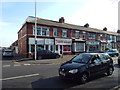
Local businesses, Watson Road, South Shore, Blackpool
Stamford Avenue on the left. Rush hour in Blackpool – traffic is queuing to get through a light-controlled junction.
Image: © Robin Stott
Taken: 20 Apr 2015
0.12 miles