IMAGES TAKEN NEAR TO
Station Terrace, BLACKPOOL, FY4 1HT
Introduction
This page details the photographs taken nearby to Station Terrace, FY4 1HT by members of the Geograph project.
The Geograph project started in 2005 with the aim of publishing, organising and preserving representative images for every square kilometre of Great Britain, Ireland and the Isle of Man.

There are currently over 7.5m images from over14,400 individuals and you can help contribute to the project by visiting https://www.geograph.org.uk
Image Map (Loading...)


Getting Data...Please wait
Leaflet Map data © OpenStreetMap
Images are licensed for reuse under creativecommons.org/licenses/by-sa/2.0
Notes
- Clicking on the map will re-center to the selected point.
- The higher the marker number, the further away the image location is from the centre of the postcode.
Image Listing (58 Images Found)
Images are licensed for reuse under creativecommons.org/licenses/by-sa/2.0
Image
Details
Distance
1
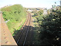
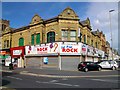
Blackpool South Shore railway station (site), Lancashire
Believed to be the site of the former Blackpool South Shore railway station, opened in 1863 by the Blackpool and Lytham Railway, closed in 1916 as it had been superseded by Blackpool South station (platforms visible in distance, and called Waterloo Road until 1932). View north from Lytham Road bridge towards former Blackpool Central station.
Image: © Nigel Thompson
Taken: 7 Oct 2012
0.05 miles
2
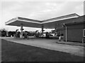
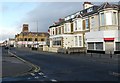
Study of a Gasoline Station
Esso, Blackpool.
This photograph is part of a series taken in homage to the American artist Ed Ruscha's 1963 publication of 'Twentysix Gasoline Stations'.
More properly known as filling stations in the UK, I am attempting to photograph as many as possible to mark the sixty year anniversary.
Image: © David Bremner
Taken: 7 Oct 2023
0.10 miles
4
Duple Social Club
Formed by The Duple Coach Builders in Blackpool
Image: © Stephen Rogerson
Taken: 29 Aug 2015
0.13 miles
5
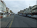
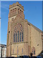
Bond Street
Looking North from the junction with Withnell Street towards Holy Trinity Church.
Image: © Gerald England
Taken: 10 Nov 2008
0.13 miles
6
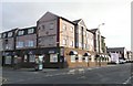
Bond Hotel
An accessible hotel catering especially for disabled guests and their carers.
Image: © Gerald England
Taken: 10 Nov 2008
0.15 miles
7
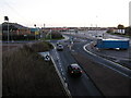
Blackpool South railway station
If the cars in this picture carry on forward through the roundabout, the road, Yeadon Way curves off to the left and goes up on to former railway embankment of the direct line from here to Kirkham. On the right in front of the hoardings is one of the former curved platforms of Blackpool South station. The one platform which remains in use is behind the hoarding. Now try and imagine this scene on a summer Sunday afternoon between the wars. A dozen or more excursion trains which brought day trippers here in the morning are sitting in the sidings, gently steaming, waiting to take the trippers back in the evening to various Lancashire mill towns.
Image: © Roger W Haworth
Taken: 24 Dec 2005
0.15 miles
8
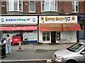
Queen Bee's Butty Bar
The Queen Bee's butty bar and Papershop Plus on Bond Street.
Image: © Gerald England
Taken: 16 Aug 2012
0.16 miles
9
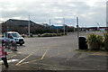
Car park beside Blackpool South station
The site of the LNWR Waterloo Road station platforms.
Image: © John Lucas
Taken: 3 Mar 2023
0.18 miles