IMAGES TAKEN NEAR TO
Swallow Close, BLACKPOOL, FY3 9NZ
Introduction
This page details the photographs taken nearby to Swallow Close, FY3 9NZ by members of the Geograph project.
The Geograph project started in 2005 with the aim of publishing, organising and preserving representative images for every square kilometre of Great Britain, Ireland and the Isle of Man.

There are currently over 7.5m images from over14,400 individuals and you can help contribute to the project by visiting https://www.geograph.org.uk
Image Map (Loading...)


Getting Data...Please wait
Leaflet Map data © OpenStreetMap
Images are licensed for reuse under creativecommons.org/licenses/by-sa/2.0
Notes
- Clicking on the map will re-center to the selected point.
- The higher the marker number, the further away the image location is from the centre of the postcode.
Image Listing (14 Images Found)
Images are licensed for reuse under creativecommons.org/licenses/by-sa/2.0
Image
Details
Distance
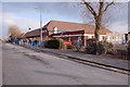
1
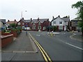
Roundabout, Preston Old Road
In Mereside, Blackpool.
Image: © Stephen Sweeney
Taken: 30 Jun 2009
0.13 miles
2
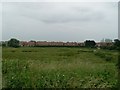
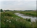
Lawson Road from across Lawson's Wetland
Image: © Stephen Sweeney
Taken: 30 Jun 2009
0.15 miles
3
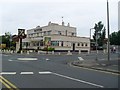
Mere Park public house
On Preston Old Road.
Image: © Stephen Sweeney
Taken: 30 Jun 2009
0.16 miles
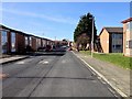
4
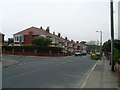
Lancaster Road housing
In Great Marton, Blackpool.
Image: © Stephen Sweeney
Taken: 30 Jun 2009
0.17 miles
5
Stanley School Blackpool
My old School from the late 40s early 50s
Image: © Keith Wright
Taken: 24 Feb 2006
0.17 miles
6
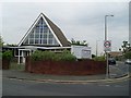
Marton United Reformed Church
On Old Preston Road, Blackpool.
Image: © Stephen Sweeney
Taken: 30 Jun 2009
0.18 miles
7
Lawson's Wetland
Created in 2007 on the site of a derelict football pitch. Owned by Blackpool Borough Council and managed by rangers. Named after the adjacent road.
Image: © Bob Jenkins
Taken: 9 Mar 2009
0.19 miles
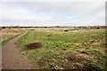
9
Lawson's Wetland
Marshy area west of Marton Mere in Blackpool.
Image: © Stephen Sweeney
Taken: 30 Jun 2009
0.20 miles
10
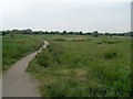
Path into Lawson's Wetland
Off Lawson Road.
Image: © Stephen Sweeney
Taken: 30 Jun 2009
0.22 miles