IMAGES TAKEN NEAR TO
Ingleway Avenue, BLACKPOOL, FY3 8LH
Introduction
This page details the photographs taken nearby to Ingleway Avenue, FY3 8LH by members of the Geograph project.
The Geograph project started in 2005 with the aim of publishing, organising and preserving representative images for every square kilometre of Great Britain, Ireland and the Isle of Man.

There are currently over 7.5m images from over14,400 individuals and you can help contribute to the project by visiting https://www.geograph.org.uk
Image Map (Loading...)


Getting Data...Please wait
Leaflet Map data © OpenStreetMap
Images are licensed for reuse under creativecommons.org/licenses/by-sa/2.0
Notes
- Clicking on the map will re-center to the selected point.
- The higher the marker number, the further away the image location is from the centre of the postcode.
Image Listing (20 Images Found)
Images are licensed for reuse under creativecommons.org/licenses/by-sa/2.0
Image
Details
Distance
5
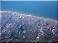
Blackpool from the air
Viewed from above The Fylde. Blackpool Football Club's stadium at Bloomfield Road is towards the left at the top, near the coast. The rightmost pier is the North Pier. Stanley Park Golf Gourse is in the left foreground.
Image: © M J Richardson
Taken: 26 Sep 2015
0.12 miles
8
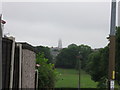
Misty Blackpool Tower
Viewed from Bardsway Avenue
Image: © Alex McGregor
Taken: 29 Jun 2010
0.16 miles