IMAGES TAKEN NEAR TO
Layton Road, BLACKPOOL, FY3 8ES
Introduction
This page details the photographs taken nearby to Layton Road, FY3 8ES by members of the Geograph project.
The Geograph project started in 2005 with the aim of publishing, organising and preserving representative images for every square kilometre of Great Britain, Ireland and the Isle of Man.

There are currently over 7.5m images from over14,400 individuals and you can help contribute to the project by visiting https://www.geograph.org.uk
Image Map
Images are licensed for reuse under creativecommons.org/licenses/by-sa/2.0
Notes
- Clicking on the map will re-center to the selected point.
- The higher the marker number, the further away the image location is from the centre of the postcode.
Image Listing (3 Images Found)
Images are licensed for reuse under creativecommons.org/licenses/by-sa/2.0
Image
Details
Distance
1
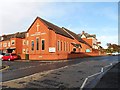
Victoria Congregational Church, Newton Drive, Blackpool
The Victoria Congregational Church was first opened, on a site in Victoria Street, in 1849. In 1968, the congregation moved to the former Methodist premises on Newton Drive as their original building had become unsafe by that time. The present church with its very distinctive windows, was dedicated in 1990.
Image: © David Dixon
Taken: 20 Oct 2013
0.22 miles
2
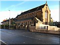
St Kentigern's Catholic Church, Newton Drive, Blackpool
St Kentigern's Catholic Church was founded in 1904.
Image: © David Dixon
Taken: 20 Oct 2013
0.23 miles
3
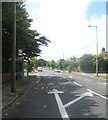
Heading for Blackpool town centre near Layton
Image: © James Denham
Taken: 24 Jul 2009
0.23 miles