IMAGES TAKEN NEAR TO
Dinmore Avenue, BLACKPOOL, FY3 7TX
Introduction
This page details the photographs taken nearby to Dinmore Avenue, FY3 7TX by members of the Geograph project.
The Geograph project started in 2005 with the aim of publishing, organising and preserving representative images for every square kilometre of Great Britain, Ireland and the Isle of Man.

There are currently over 7.5m images from over14,400 individuals and you can help contribute to the project by visiting https://www.geograph.org.uk
Image Map
Images are licensed for reuse under creativecommons.org/licenses/by-sa/2.0
Notes
- Clicking on the map will re-center to the selected point.
- The higher the marker number, the further away the image location is from the centre of the postcode.
Image Listing (11 Images Found)
Images are licensed for reuse under creativecommons.org/licenses/by-sa/2.0
Image
Details
Distance
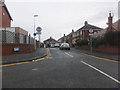
1
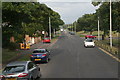
A586 and turn-off onto Dinmore Avenue, Grange Farm estate
Image: © Chris
Taken: 31 Jul 2014
0.09 miles
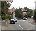
2
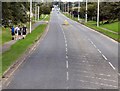
Garstang Road West
The A586 out of Blackpool.
Image: © Gerald England
Taken: 27 Aug 2016
0.11 miles
3
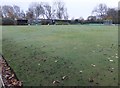
Boundary Park Bowling Club
The nearby notice board says:
"We are a friendly club and welcome new members to join as team players or simply to enjoy our numerous social events".
(Very reasonable rates, too!)
Image: © Barbara Carr
Taken: 17 Nov 2013
0.14 miles
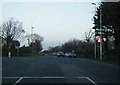
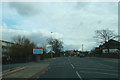
6
Blackpool Old Road
The B5268 through Little Carleton.
Image: © Gerald England
Taken: 27 Aug 2016
0.18 miles
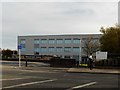
9
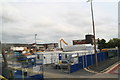
Developments at or next to the Blackpool Sixth Form College
Image: © Chris
Taken: 31 Jul 2014
0.24 miles
10
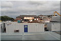
Developments at or next to the Blackpool Sixth Form College
Image: © Chris
Taken: 31 Jul 2014
0.24 miles