IMAGES TAKEN NEAR TO
Holmfield Road, BLACKPOOL, FY2 9RD
Introduction
This page details the photographs taken nearby to Holmfield Road, FY2 9RD by members of the Geograph project.
The Geograph project started in 2005 with the aim of publishing, organising and preserving representative images for every square kilometre of Great Britain, Ireland and the Isle of Man.

There are currently over 7.5m images from over14,400 individuals and you can help contribute to the project by visiting https://www.geograph.org.uk
Image Map
Images are licensed for reuse under creativecommons.org/licenses/by-sa/2.0
Notes
- Clicking on the map will re-center to the selected point.
- The higher the marker number, the further away the image location is from the centre of the postcode.
Image Listing (88 Images Found)
Images are licensed for reuse under creativecommons.org/licenses/by-sa/2.0
Image
Details
Distance
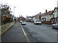
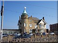
2
Carlin Gate
Blackpool is generally thought of as simply a brash, kiss-me-quick, Golden Mile resort, but it also has large areas of prosperous middle class suburbs.
Image: © Alan Murray-Rust
Taken: 7 Nov 2009
0.05 miles
3
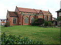
St Stephen's Church
On Holmfield Road, Blackpool.
Image: © JThomas
Taken: 19 Oct 2013
0.07 miles


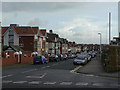
8
The Circus Casino on Blackpool North Shore
Image: © Raymond Knapman
Taken: 29 Sep 2011
0.10 miles