IMAGES TAKEN NEAR TO
Warbreck Drive, BLACKPOOL, FY2 9LH
Introduction
This page details the photographs taken nearby to Warbreck Drive, FY2 9LH by members of the Geograph project.
The Geograph project started in 2005 with the aim of publishing, organising and preserving representative images for every square kilometre of Great Britain, Ireland and the Isle of Man.

There are currently over 7.5m images from over14,400 individuals and you can help contribute to the project by visiting https://www.geograph.org.uk
Image Map
Images are licensed for reuse under creativecommons.org/licenses/by-sa/2.0
Notes
- Clicking on the map will re-center to the selected point.
- The higher the marker number, the further away the image location is from the centre of the postcode.
Image Listing (76 Images Found)
Images are licensed for reuse under creativecommons.org/licenses/by-sa/2.0
Image
Details
Distance
3
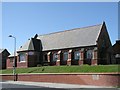
Cavendish Road Congregational, Bispham
Founded before 1895 this building was in use when the image was taken. The date stone just visible in the brick wall states "Bethel Chapel 1854"
Image: © Steve Houldsworth
Taken: Unknown
0.09 miles
4

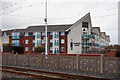
Admiral Point flat, South Promenade, Blackpool
Image: © Ian S
Taken: 18 Feb 2019
0.10 miles
5
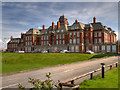
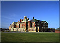
Miners' Convalescent Home, Blackpool
The Lancashire & North Staffordshire Miners' Convalescent Home at Bispham, was built between 1925 and 1927 in Baroque Revival style. It is built of red and light engineering brick, with terracotta dressings mainly to the ground floor. Towards the rear of the building there is a tower with an ogee cap.
The building continued to function as a convalescent home until the 1980s and in 2005, was turned into apartments (Admiral Point http://www.admiralpointblackpool.info/history.html ). It is a grade II listed building (List entry Number: 1116645 https://historicengland.org.uk/listing/the-list/list-entry/1116645 Historic England).
Image: © David Dixon
Taken: 13 Aug 2017
0.11 miles
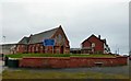
6
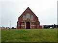
Bispham United Reformed Church
On the corner of Cavendish Road and Warbreck Drive.
Image: © Gerald England
Taken: 10 Apr 2018
0.11 miles
7
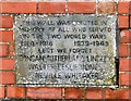
Memorial Wall
An inscribed stone in the wall surrounding Bispham United Reformed Church Image reads:
THIS WALL WAS ERECTED IN
MEMORY OF ALL WHO SERVED
IN THE TWO WORLD WARS
1914-1918 ____ 1939-1945
LEST WE FORGET
DUNCAN SUTHERLAND LINDLEY
WALTER LESLIE JONES
NEVILLE WHITAKER
Image: © Gerald England
Taken: 10 Apr 2018
0.11 miles
8
Bispham United Reformed Church
On the corner of Cavendish Road and Warbreck Drive. The wall in front is a war memorial Image
Image: © Gerald England
Taken: 10 Apr 2018
0.11 miles