IMAGES TAKEN NEAR TO
Blackfen Place, BLACKPOOL, FY2 0XG
Introduction
This page details the photographs taken nearby to Blackfen Place, FY2 0XG by members of the Geograph project.
The Geograph project started in 2005 with the aim of publishing, organising and preserving representative images for every square kilometre of Great Britain, Ireland and the Isle of Man.

There are currently over 7.5m images from over14,400 individuals and you can help contribute to the project by visiting https://www.geograph.org.uk
Image Map
Images are licensed for reuse under creativecommons.org/licenses/by-sa/2.0
Notes
- Clicking on the map will re-center to the selected point.
- The higher the marker number, the further away the image location is from the centre of the postcode.
Image Listing (6 Images Found)
Images are licensed for reuse under creativecommons.org/licenses/by-sa/2.0
Image
Details
Distance
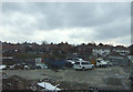
1
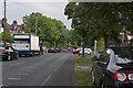
Devonshire Road bridge works causing delays
Image: © Ian Greig
Taken: 8 Jun 2018
0.15 miles
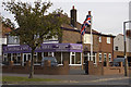
2
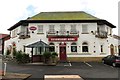
The Devonshire Arms on Devonshire Road
The Devonshire Arms is a Sizzling Pub.
Image: © Steve Daniels
Taken: 18 Sep 2013
0.17 miles
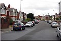
6
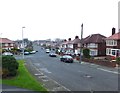
Mansfield Road, Hoohill
Residential street to the west of the A586.
Image: © Barbara Carr
Taken: 17 Nov 2013
0.24 miles