IMAGES TAKEN NEAR TO
Runcorn Avenue, BLACKPOOL, FY2 0PS
Introduction
This page details the photographs taken nearby to Runcorn Avenue, FY2 0PS by members of the Geograph project.
The Geograph project started in 2005 with the aim of publishing, organising and preserving representative images for every square kilometre of Great Britain, Ireland and the Isle of Man.

There are currently over 7.5m images from over14,400 individuals and you can help contribute to the project by visiting https://www.geograph.org.uk
Image Map
Images are licensed for reuse under creativecommons.org/licenses/by-sa/2.0
Notes
- Clicking on the map will re-center to the selected point.
- The higher the marker number, the further away the image location is from the centre of the postcode.
Image Listing (5 Images Found)
Images are licensed for reuse under creativecommons.org/licenses/by-sa/2.0
Image
Details
Distance
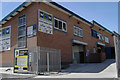
3
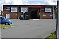
Entrance to S & S Timber, Chorley Road, Blackpool
Image: © Tom Richardson
Taken: 5 Jul 2008
0.19 miles
4
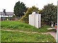
Smoke Detector
This is one of many roadside Air Quality testing stations used to monitor pollution levels in sensitive areas. This one is located at the junction of Mowbray Drive, Little Carleton, Blackpool
Image: © Roger May
Taken: 7 Sep 2005
0.20 miles
5
Industrial units, Chorley Road, Blackpool
Image: © Tom Richardson
Taken: 5 Jul 2008
0.21 miles