IMAGES TAKEN NEAR TO
Chaucer Place, BLACKPOOL, FY2 0GL
Introduction
This page details the photographs taken nearby to Chaucer Place, FY2 0GL by members of the Geograph project.
The Geograph project started in 2005 with the aim of publishing, organising and preserving representative images for every square kilometre of Great Britain, Ireland and the Isle of Man.

There are currently over 7.5m images from over14,400 individuals and you can help contribute to the project by visiting https://www.geograph.org.uk
Image Map
Images are licensed for reuse under creativecommons.org/licenses/by-sa/2.0
Notes
- Clicking on the map will re-center to the selected point.
- The higher the marker number, the further away the image location is from the centre of the postcode.
Image Listing (14 Images Found)
Images are licensed for reuse under creativecommons.org/licenses/by-sa/2.0
Image
Details
Distance
1
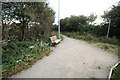
Litter Strewn Public Footpath
The litter in this area spoils the attempt to have pleasant open spaces and access tracks.
Image: © Bob Jenkins
Taken: 13 Oct 2009
0.08 miles
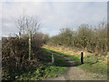
2
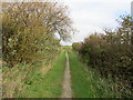
Path leading to Bispham Road
Short path connecting Faraday Way to Bispham Road
Image: © Chris Heaton
Taken: 5 Oct 2011
0.14 miles
4
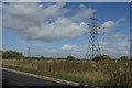
Electricity pylons
...and rough grassland hiding Ryscar Farm
Image: © Ian Greig
Taken: 11 Sep 2018
0.15 miles
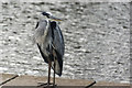
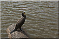
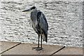
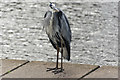
6
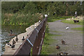
A cormorant (left) a heron (near centre) and a life-like carving of a heron (right)
Together with sundry ducks
Image: © Ian Greig
Taken: 11 Sep 2018
0.16 miles