IMAGES TAKEN NEAR TO
Birkdale Avenue, BLACKPOOL, FY2 0ES
Introduction
This page details the photographs taken nearby to Birkdale Avenue, FY2 0ES by members of the Geograph project.
The Geograph project started in 2005 with the aim of publishing, organising and preserving representative images for every square kilometre of Great Britain, Ireland and the Isle of Man.

There are currently over 7.5m images from over14,400 individuals and you can help contribute to the project by visiting https://www.geograph.org.uk
Image Map
Images are licensed for reuse under creativecommons.org/licenses/by-sa/2.0
Notes
- Clicking on the map will re-center to the selected point.
- The higher the marker number, the further away the image location is from the centre of the postcode.
Image Listing (6 Images Found)
Images are licensed for reuse under creativecommons.org/licenses/by-sa/2.0
Image
Details
Distance
1
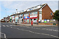
Ashfield Road Post Office and other Shops
Image: © David Dixon
Taken: 26 Aug 2019
0.13 miles
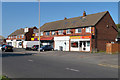
6
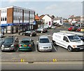
Bispham Village
The car park on the corner of Redbank Road and All Hallows Road.
Image: © Gerald England
Taken: 8 Apr 2013
0.25 miles