IMAGES TAKEN NEAR TO
All Hallows Road, BLACKPOOL, FY2 0AS
Introduction
This page details the photographs taken nearby to All Hallows Road, FY2 0AS by members of the Geograph project.
The Geograph project started in 2005 with the aim of publishing, organising and preserving representative images for every square kilometre of Great Britain, Ireland and the Isle of Man.

There are currently over 7.5m images from over14,400 individuals and you can help contribute to the project by visiting https://www.geograph.org.uk
Image Map
Images are licensed for reuse under creativecommons.org/licenses/by-sa/2.0
Notes
- Clicking on the map will re-center to the selected point.
- The higher the marker number, the further away the image location is from the centre of the postcode.
Image Listing (12 Images Found)
Images are licensed for reuse under creativecommons.org/licenses/by-sa/2.0
Image
Details
Distance
1
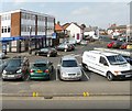
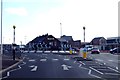
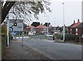
Bispham Village
The car park on the corner of Redbank Road and All Hallows Road.
Image: © Gerald England
Taken: 8 Apr 2013
0.05 miles
3
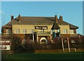
Red Lion Inn, viewed from Devonshire Road
Image: © Peter Bond
Taken: 15 Jan 2012
0.12 miles
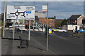
4
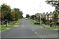
Approaching the roundabout from Red Bank Road
Image: © Steve Daniels
Taken: 27 Aug 2014
0.13 miles
7
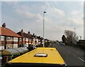
Bispham Road
The A587 Cleveleys to Great Marton road viewed from the top of a double-deck bus looking over the roof of a single-deck bus.
Image: © Gerald England
Taken: 8 Apr 2013
0.17 miles
8
Approaching the double roundabout on Bispham Road
At the roundabout, the northern end of Bispham Road meets Devonshire Road, which runs in a north/south direction, and Red Bank Road, which runs approximately east/west.
Image: © Barbara Carr
Taken: 17 Nov 2013
0.17 miles
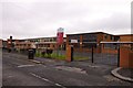
9
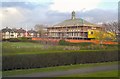
Bispham Library
Work is ongoing at Bispham Library involving the demolition of the existing health centre and dental clinic and construction of a single storey rear extension to the former library building incorporating sensory pod in association with the use of the premises as a day centre for people with learning disabilities with associated landscaping and new drop off/pick up area.
Image: © Gerald England
Taken: 10 Apr 2012
0.21 miles