IMAGES TAKEN NEAR TO
Devonshire Road, BLACKPOOL, FY2 0AR
Introduction
This page details the photographs taken nearby to Devonshire Road, FY2 0AR by members of the Geograph project.
The Geograph project started in 2005 with the aim of publishing, organising and preserving representative images for every square kilometre of Great Britain, Ireland and the Isle of Man.

There are currently over 7.5m images from over14,400 individuals and you can help contribute to the project by visiting https://www.geograph.org.uk
Image Map
Images are licensed for reuse under creativecommons.org/licenses/by-sa/2.0
Notes
- Clicking on the map will re-center to the selected point.
- The higher the marker number, the further away the image location is from the centre of the postcode.
Image Listing (7 Images Found)
Images are licensed for reuse under creativecommons.org/licenses/by-sa/2.0
Image
Details
Distance
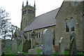
2
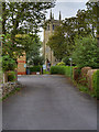
Bispham Parish Church (All Hallows)
Bispham Parish Church, also known as All Hallows Church is a Grade II Listed Building (Historic England List Entry Number: 1362390 https://historicengland.org.uk/listing/the-list/list-entry/1362390 ). The present church dates from 1883.
Image: © David Dixon
Taken: 26 Aug 2019
0.12 miles
3
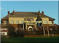
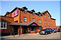
Red Lion Inn, viewed from Devonshire Road
Image: © Peter Bond
Taken: 15 Jan 2012
0.12 miles
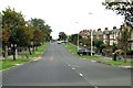
7
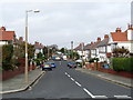
Delphene Avenue, Bispham
One of many streets behind the Fylde Coast at Norbreck and Bispham
Image: © Chris Heaton
Taken: 5 Oct 2011
0.17 miles