IMAGES TAKEN NEAR TO
Park Road, BLACKPOOL, FY1 5PE
Introduction
This page details the photographs taken nearby to Park Road, FY1 5PE by members of the Geograph project.
The Geograph project started in 2005 with the aim of publishing, organising and preserving representative images for every square kilometre of Great Britain, Ireland and the Isle of Man.

There are currently over 7.5m images from over14,400 individuals and you can help contribute to the project by visiting https://www.geograph.org.uk
Image Map (Loading...)


Getting Data...Please wait
Leaflet Map data © OpenStreetMap
Images are licensed for reuse under creativecommons.org/licenses/by-sa/2.0
Notes
- Clicking on the map will re-center to the selected point.
- The higher the marker number, the further away the image location is from the centre of the postcode.
Image Listing (20 Images Found)
Images are licensed for reuse under creativecommons.org/licenses/by-sa/2.0
Image
Details
Distance
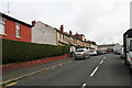
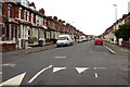
2
Keswick Road, Blackpool
The streets in this area of the suburbs have Cumbrian names.
Image: © Barbara Carr
Taken: 26 Oct 2013
0.02 miles
4
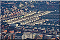
Blackpool : Housing & Scenery
Looking towards rooftops and houses from the Blackpool Tower.
Image: © Lewis Clarke
Taken: 12 Oct 2014
0.07 miles
7
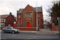
Ripon Rd Christian Fellowship, Blackpool
Foundd in 2002 it was still in use when this image was taken.
Image: © Steve Houldsworth
Taken: Unknown
0.18 miles
9
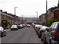
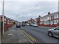
Westmoreland Avenue, Blackpool
Looking down this road, the eye is drawn to the stands of Blackpool F.C.
Image: © Neil Owen
Taken: 2 May 2010
0.22 miles