IMAGES TAKEN NEAR TO
Back Kingsland Grove, BLACKPOOL, FY1 5NW
Introduction
This page details the photographs taken nearby to Back Kingsland Grove, FY1 5NW by members of the Geograph project.
The Geograph project started in 2005 with the aim of publishing, organising and preserving representative images for every square kilometre of Great Britain, Ireland and the Isle of Man.

There are currently over 7.5m images from over14,400 individuals and you can help contribute to the project by visiting https://www.geograph.org.uk
Image Map (Loading...)


Getting Data...Please wait
Leaflet Map data © OpenStreetMap
Images are licensed for reuse under creativecommons.org/licenses/by-sa/2.0
Notes
- Clicking on the map will re-center to the selected point.
- The higher the marker number, the further away the image location is from the centre of the postcode.
Image Listing (9 Images Found)
Images are licensed for reuse under creativecommons.org/licenses/by-sa/2.0
Image
Details
Distance
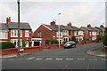
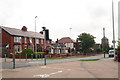
2
Cunliffe Road, Blackpool
An impressive street of terraced houses, curving away up a slight rise.
Image: © Chris
Taken: 31 Jul 2014
0.12 miles
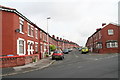
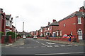
3
Condor Grove, approaching junction of Park Road
Image: © Peter Bond
Taken: 15 Jan 2012
0.12 miles
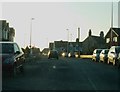
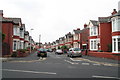
5
Park Road after the junction with Bloomfield Road
Image: © Chris
Taken: 31 Jul 2014
0.20 miles
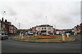
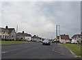
9
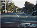
Blackpool : Whitegate Drive A583
Looking along Whitegate Drive at the road junction with Knowsley Avenue.
Image: © Lewis Clarke
Taken: 12 Oct 2014
0.23 miles