IMAGES TAKEN NEAR TO
Raikes Parade, BLACKPOOL, FY1 4EL
Introduction
This page details the photographs taken nearby to Raikes Parade, FY1 4EL by members of the Geograph project.
The Geograph project started in 2005 with the aim of publishing, organising and preserving representative images for every square kilometre of Great Britain, Ireland and the Isle of Man.

There are currently over 7.5m images from over14,400 individuals and you can help contribute to the project by visiting https://www.geograph.org.uk
Image Map (Loading...)


Getting Data...Please wait
Leaflet Map data © OpenStreetMap
Images are licensed for reuse under creativecommons.org/licenses/by-sa/2.0
Notes
- Clicking on the map will re-center to the selected point.
- The higher the marker number, the further away the image location is from the centre of the postcode.
Image Listing (53 Images Found)
Images are licensed for reuse under creativecommons.org/licenses/by-sa/2.0
Image
Details
Distance
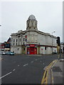
1
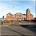
Blackpool Salvation Army Citadel
Blackpool Citadel of the Salvation Army was founded in 1981. For many years Blackpool SA Citadel was in Coronation Street providing easy access to the Promenade. It is now located in Raikes Parade within a building which originally housed Blackpool Grammar School.
The Grade II listed http://list.english-heritage.org.uk/resultsingle.aspx?uid=1205886 building was built 1904-05 as Raikes Road Technical School to a design by Potts, Son and Hennings. It was later the Grammar School and is currently the premises of the Salvation Army. It is constructed of red brick with grey terracotta dressings and quoins in the Baroque style. It has slate roofs, with copper domes. Its plan is 'U'-shaped, with receding wings. The tower to the south-west is square with three storeys and has an octagonal lantern with a copper dome and finial.
Citadel website: http://www.salvationarmy.org.uk/blackpool-citadel
Insignia: Image
Image: © Gerald England
Taken: 4 Mar 2014
0.02 miles
2
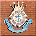
Blood and Fire
Insignia on the wall of the Blackpool Citadel Image
Image: © Gerald England
Taken: 4 Mar 2014
0.02 miles
3
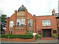
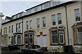
Leamington Rd United Hebrew, Blackpool
It was founded in 1890, the date stone on the building has a date from early 1900 and it was still in use when the image was taken.
Image: © Steve Houldsworth
Taken: Unknown
0.02 miles
4
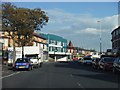
Blackpool : Church Street A583
Church Street heading through Blackpool.
Image: © Lewis Clarke
Taken: 12 Oct 2014
0.08 miles
6
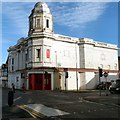
The Regent Cinema
Opened on 17th January 1921, the Regent Picture House has a magnificent white faience tiled façade on this corner site. A tall domed tower is above the entrance foyer. The tiling is Middleton's fireclay ceramo.
In 1969 it began running bingo on several nights a weeks and by 1971 had become a full time bingo club. In recent years it operated as Riley's snooker hall, but closed in 2010.
It was sold at auction in February 2013 and has since opened as an antiques centre. Future plans are to bring it back into use as a cinema and live performance venue.
Facebook group: https://www.facebook.com/groups/165002553652335/
Image: © Gerald England
Taken: 4 Mar 2014
0.09 miles
7
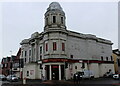
The Regent, Blackpool
Former cinema opened in 1921, supporting a distinctive white tilled facade. It finally closed down in the early 1970's seeing life as a bingo venue and snooker hall.
At present The Regent is an antiques and collectables emporium.
Image: © Chris Heaton
Taken: 3 Dec 2021
0.10 miles
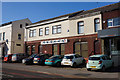
8
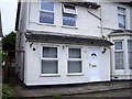
Terraced Houses on Regent Road, Blackpool
A certain geographer tarried in one of these houses in his misspent youth as a student.
Image: © Chris Heaton
Taken: 3 Dec 2021
0.10 miles
9
Rileys, Church Street, Blackpool
Watched the film "The Longest Day" here when it was the Palladium Cinema
Image: © Alexander P Kapp
Taken: 6 Jul 2010
0.10 miles
10
Blackpool Magicians Club
On Caunce Street, Blackpool.
Image: © Ian S
Taken: 15 Feb 2019
0.11 miles