IMAGES TAKEN NEAR TO
Hamilton Drive, STIRLING, FK9 5SA
Introduction
This page details the photographs taken nearby to Hamilton Drive, FK9 5SA by members of the Geograph project.
The Geograph project started in 2005 with the aim of publishing, organising and preserving representative images for every square kilometre of Great Britain, Ireland and the Isle of Man.

There are currently over 7.5m images from over14,400 individuals and you can help contribute to the project by visiting https://www.geograph.org.uk
Image Map
Images are licensed for reuse under creativecommons.org/licenses/by-sa/2.0
Notes
- Clicking on the map will re-center to the selected point.
- The higher the marker number, the further away the image location is from the centre of the postcode.
Image Listing (6 Images Found)
Images are licensed for reuse under creativecommons.org/licenses/by-sa/2.0
Image
Details
Distance
1
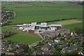
Wallace High School, Causewayhead
The new school, which opened in 2008, from the top of the Wallace Monument on Abbey Craig.
Image: © Mike Pennington
Taken: 4 May 2009
0.15 miles
2
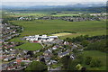
Wallace High School, Causewayhead, Stirling, from the Wallace Monument
Image: © Mike Pennington
Taken: 8 Jun 2015
0.15 miles
3
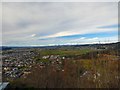
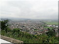
View from the Wallace Monument
A westerly view over Wallace High School and the housing estates of Causewayhead towards more distant snow-clad hills.
Image: © Gerald England
Taken: 22 Mar 2017
0.16 miles
4
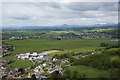
Wallace High School, Causewayhead, Stirling, from the Wallace Monument
Image: © Mike Pennington
Taken: 8 Jun 2015
0.17 miles
5
Looking down on Stirling from the Wallace Memorial
Image: © Eirian Evans
Taken: 7 Sep 2021
0.20 miles
6
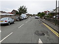
Cleuch Road in Stirling
Looking north-westward.
Image: © Peter Wood
Taken: 4 Oct 2017
0.25 miles