IMAGES TAKEN NEAR TO
Manor Loan, STIRLING, FK9 5QD
Introduction
This page details the photographs taken nearby to Manor Loan, FK9 5QD by members of the Geograph project.
The Geograph project started in 2005 with the aim of publishing, organising and preserving representative images for every square kilometre of Great Britain, Ireland and the Isle of Man.

There are currently over 7.5m images from over14,400 individuals and you can help contribute to the project by visiting https://www.geograph.org.uk
Image Map (Loading...)


Getting Data...Please wait
Leaflet Map data © OpenStreetMap
Images are licensed for reuse under creativecommons.org/licenses/by-sa/2.0
Notes
- Clicking on the map will re-center to the selected point.
- The higher the marker number, the further away the image location is from the centre of the postcode.
Image Listing (7 Images Found)
Images are licensed for reuse under creativecommons.org/licenses/by-sa/2.0
Image
Details
Distance
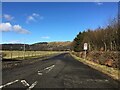
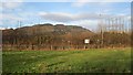
1

Farmland at Manor Powis
Farmland near Manor Powis, with the prominent south-facing escarpment of the Ochil Hills visible in the distance.
Image: © William Starkey
Taken: 5 Jul 2012
0.10 miles
3
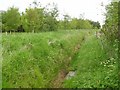
Ditch off Manor Loan
This part of the Forth flood plain has had a lot of woodland planted. The burn is more of a drainage ditch.
Image: © Richard Webb
Taken: 4 Jun 2006
0.12 miles
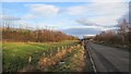
4
A narrow field, Manor Powis
The field is a remnant of farmland between the new A907 and the original alignment.
Image: © Richard Webb
Taken: 1 Feb 2013
0.21 miles
5
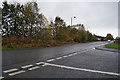
Old alignment, A907
The road was rebuilt around 2000 on a new course to the north.
Image: © Richard Webb
Taken: 1 Feb 2013
0.21 miles