IMAGES TAKEN NEAR TO
Hill Foots Road, STIRLING, FK9 5PY
Introduction
This page details the photographs taken nearby to Hill Foots Road, FK9 5PY by members of the Geograph project.
The Geograph project started in 2005 with the aim of publishing, organising and preserving representative images for every square kilometre of Great Britain, Ireland and the Isle of Man.

There are currently over 7.5m images from over14,400 individuals and you can help contribute to the project by visiting https://www.geograph.org.uk
Image Map (Loading...)


Getting Data...Please wait
Leaflet Map data © OpenStreetMap
Images are licensed for reuse under creativecommons.org/licenses/by-sa/2.0
Notes
- Clicking on the map will re-center to the selected point.
- The higher the marker number, the further away the image location is from the centre of the postcode.
Image Listing (19 Images Found)
Images are licensed for reuse under creativecommons.org/licenses/by-sa/2.0
Image
Details
Distance
1
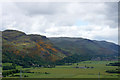
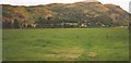
Blairlogie from the Wallace Monument
The hill of Dumyat beyond.
Image: © Mike Pennington
Taken: 8 Jun 2015
0.04 miles
3
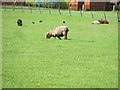
One of our little experiments
In 1983 we had a run of black Ryeland lambs Image due to a "dodgy" tup. Ryelands should be white Image, and even a spot can get a sheep condemned. Originally thought worthless, the other qualities of the lambs combined with an influx of ex hippies into the area (around Leominster, Herefordshire) looking for interesting craft materials suggested that we keep and breed from the lambs. The lambs are black, but the fleeces are a variety of soft browns in colour.
This proved controversial and led to some nasty conflicts with traditionalists. The sheep now occupy an "almost breed" niche and there are some show classes for them.
They have spread and occasionally I spot one in my travels, but usually see them in their birthplace
Image: © Richard Webb
Taken: 14 May 2011
0.11 miles
4
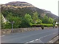
Blairlogie Reading Room on EU Referendum day
The Reading Room is the village hall for the village (although more correctly a clachan) of Blairlogie. The hall is owned and managed by a charitable trust on behalf of the village. It is used for typical village activities and also normally hosts a polling station for elections and referenda.
In this image it is being used as a polling station for the EU Referendum on 23rd June 2016.
Image: © Doug Lee
Taken: 23 Jun 2016
0.12 miles
6
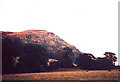
Hills above Blairlogie east of Stirling
Image: © nick macneill
Taken: 19 Aug 1995
0.16 miles
7
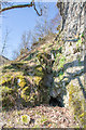
Collapsed lower adit of the Blairlogie Copper Mine
This is the lower adit of the Blairlogie Copper Mine, the upper adit of which is shown in Image
The sides of the adit have collapsed leaving only the very top of the adit open. In addition, the tunnel roof has collapsed a couple of metres behind this point leaving a small depression in the ground.
This would have been the original entrance to the mine which was worked from this point through the rock to, eventually, emerge at the upper adit.
Image: © Doug Lee
Taken: 27 Mar 2017
0.18 miles
8
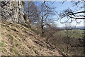
In the woodland above Blairlogie
This is the view through the woodland above Blairlogie out into the Forth Valley. This position is just in front of Image
Image: © Doug Lee
Taken: 27 Mar 2017
0.18 miles
9
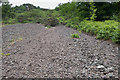
Spoil from the Blairlogie copper mine
This is the spoil heap from the Blairlogie copper mine. The mine's adit, shown in Image, is hidden in the vegetation fifteen to twenty metres above and to the right of the visible section of this spoil heap.
Image: © Doug Lee
Taken: 19 Jun 2016
0.20 miles
10
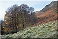
Autumnal trees at the base of Dumyat's western ridge
Image: © Doug Lee
Taken: 21 Nov 2016
0.21 miles