IMAGES TAKEN NEAR TO
STIRLING, FK9 5PS
Introduction
This page details the photographs taken nearby to FK9 5PS by members of the Geograph project.
The Geograph project started in 2005 with the aim of publishing, organising and preserving representative images for every square kilometre of Great Britain, Ireland and the Isle of Man.

There are currently over 7.5m images from over14,400 individuals and you can help contribute to the project by visiting https://www.geograph.org.uk
Image Map (Loading...)


Getting Data...Please wait
Leaflet Map data © OpenStreetMap
Images are licensed for reuse under creativecommons.org/licenses/by-sa/2.0
Notes
- Clicking on the map will re-center to the selected point.
- The higher the marker number, the further away the image location is from the centre of the postcode.
Image Listing (9 Images Found)
Images are licensed for reuse under creativecommons.org/licenses/by-sa/2.0
Image
Details
Distance
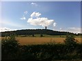
1
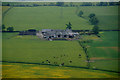
Powis Mains, near Stirling
From the top of the Wallace Monument.
Image: © Mike Pennington
Taken: 10 Jun 2013
0.02 miles
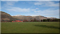
2
Powis Mains and surrounding farmland from Wallace Monument
Image: © Colin Park
Taken: 17 Apr 1982
0.03 miles
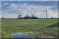

6
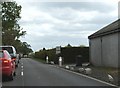
Drivers and Drovers
Looking south down the A91, just beside Powis Manor Farm.
The north bound traffic has been blocked with a farm Land Rover to allow the sheep to be walked along the road to first access road on left towards Manor Farm.
Image: © Derek Ferris
Taken: 18 May 2007
0.10 miles
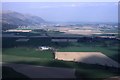
9
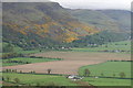
Powis Mains, Blairlogie and the Ochil Hills
Powis Mains Cottages are in the foreground, Blair Logie is nestled in by the steep SW slopes of the Ochils and the three hills are Dumyat, Myreton Hill and Craig Leith.
Image: © Mike Pennington
Taken: 4 May 2009
0.17 miles