IMAGES TAKEN NEAR TO
Causewayhead, STIRLING, FK9 5PL
Introduction
This page details the photographs taken nearby to FK9 5PL by members of the Geograph project.
The Geograph project started in 2005 with the aim of publishing, organising and preserving representative images for every square kilometre of Great Britain, Ireland and the Isle of Man.

There are currently over 7.5m images from over14,400 individuals and you can help contribute to the project by visiting https://www.geograph.org.uk
Image Map (Loading...)


Getting Data...Please wait
Leaflet Map data © OpenStreetMap
Images are licensed for reuse under creativecommons.org/licenses/by-sa/2.0
Notes
- Clicking on the map will re-center to the selected point.
- The higher the marker number, the further away the image location is from the centre of the postcode.
Image Listing (5 Images Found)
Images are licensed for reuse under creativecommons.org/licenses/by-sa/2.0
Image
Details
Distance
1
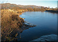
River Forth near Cambuskenneth
The image shows a small creek where the Logie Burn joins the Forth near Cambuskenneth
Image: © William Starkey
Taken: 10 Nov 2010
0.11 miles
2
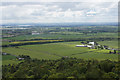
Broom, Cambuskenneth, from the Wallace Monument
Image: © Mike Pennington
Taken: 8 Jun 2015
0.11 miles
3
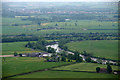
Broom farm, beside the Forth, near Stirling
Taken from the top of the Wallace Monument.
Image: © Mike Pennington
Taken: 10 Jun 2013
0.18 miles
4
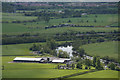
Broom farm, Cambuskenneth, from the Wallace Monument
Image: © Mike Pennington
Taken: 8 Jun 2015
0.19 miles
5
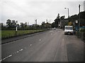
Craigmill
Alloa Road passing through Craigmill.
Image: © Richard Webb
Taken: 18 Sep 2009
0.23 miles