IMAGES TAKEN NEAR TO
Alloa Road, STIRLING, FK9 5LJ
Introduction
This page details the photographs taken nearby to Alloa Road, FK9 5LJ by members of the Geograph project.
The Geograph project started in 2005 with the aim of publishing, organising and preserving representative images for every square kilometre of Great Britain, Ireland and the Isle of Man.

There are currently over 7.5m images from over14,400 individuals and you can help contribute to the project by visiting https://www.geograph.org.uk
Image Map (Loading...)


Getting Data...Please wait
Leaflet Map data © OpenStreetMap
Images are licensed for reuse under creativecommons.org/licenses/by-sa/2.0
Notes
- Clicking on the map will re-center to the selected point.
- The higher the marker number, the further away the image location is from the centre of the postcode.
Image Listing (125 Images Found)
Images are licensed for reuse under creativecommons.org/licenses/by-sa/2.0
Image
Details
Distance
1
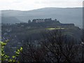
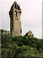
Wallace Monument
The view you would get of Stirling Castle from the Wallace Monument.
Vice versa: http://www.geograph.org.uk/photo/832326
Image: © Simon Johnston
Taken: 27 Apr 2008
0.03 miles
2
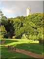
Park beneath Abbey Craig
Well appointed park beneath Abbey Craig and that Victorian predecessor to the wind turbine, the Wallace Monument.
Image: © Richard Webb
Taken: 29 Aug 2010
0.06 miles
3

Park, Causewayhead
The park is very popular and the autumnal colours are showing well on Abbey Craig.
High above is the Wallace Monument. The tower was completed in 1869 to a design by John Rochead and built at a cost of £18,000.
The 220 foot, sandstone monument is built on the alleged spot where William Wallace watched the English Army gather before the battle of Stirling Bridge.
The battle of Stirling Bridge took place on 11th September 1297. The battle in which the Scots under William Wallace and Andrew Moray defeated the English army, inflicting heavy losses and briefly freeing most of Scotland from English rule. Moray was mortally wounded in the battle.
Image: © Maigheach-gheal
Taken: 16 Oct 2010
0.06 miles
4

Causewayhead Park
Beneath Abbey Craig with a well developed playground. Perfect family afternoon's out are aided by the proximity of Corrieri's ice cream (and pizza) parlour.
Image: © Richard Webb
Taken: 12 May 2018
0.06 miles
5
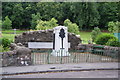
War memorial at Causewayhead
In a small park overlooked by the Wallace Monument.
Image: © Bill Boaden
Taken: 9 Aug 2013
0.07 miles
6
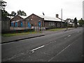
Remploy, Alloa Road
The provider of work for disabled people had recently contracted with factory closures. The Stirling factory under Abbey Craig survived and is still working.
Image: © Richard Webb
Taken: 18 Sep 2009
0.08 miles
8
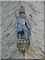
Wallace Monument
Statue of William Wallace above our heads
Image: © Karel
Taken: 2 Jul 2009
0.09 miles
9
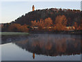
Abbey Craig
The Wallace Monument reflected in the River Forth. The crag is named after Cambuskenneth Abbey, which formerly owned the land.
Image: © Andrew Smith
Taken: 3 Feb 2007
0.09 miles
10
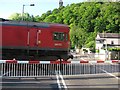
Ladysneuk Road Level Crossing
A coal train heading for Longannet. The level crossing has recently been rebuilt as part of the reopening of the railway, but will wreck your car if not crossed with care - there are issues with the quality of construction.
Image: © Richard Webb
Taken: 23 May 2012
0.09 miles