IMAGES TAKEN NEAR TO
Castle Road, STIRLING, FK9 5JB
Introduction
This page details the photographs taken nearby to Castle Road, FK9 5JB by members of the Geograph project.
The Geograph project started in 2005 with the aim of publishing, organising and preserving representative images for every square kilometre of Great Britain, Ireland and the Isle of Man.

There are currently over 7.5m images from over14,400 individuals and you can help contribute to the project by visiting https://www.geograph.org.uk
Image Map (Loading...)


Getting Data...Please wait
Leaflet Map data © OpenStreetMap
Images are licensed for reuse under creativecommons.org/licenses/by-sa/2.0
Notes
- Clicking on the map will re-center to the selected point.
- The higher the marker number, the further away the image location is from the centre of the postcode.
Image Listing (23 Images Found)
Images are licensed for reuse under creativecommons.org/licenses/by-sa/2.0
Image
Details
Distance
1
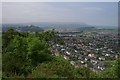
View towards Causewayhead from Wallace Monument
Image: © Colin Park
Taken: 17 Apr 1982
0.04 miles
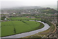
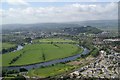
2
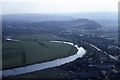
Causewayhead from the Wallace Monument
Looking south west over Causewayhead and the River Forth towards Stirling Castle.
Image: © Gordon Hatton
Taken: Unknown
0.05 miles
3
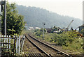
Site of Causewayhead station, 1986
View NE, towards Alloa and Dunfermline: ex-NBR Stirling - Alloa - Dunfermline line. The station had been closed earlier (4/7/55), the Stirling - Alloa - Dunfermline passenger service ceasing from 4/10/68, but the line remained open for occasional goods. However, it was restored again, to a rebuilt station at Alloa on 15/5/08.
Image: © Ben Brooksbank
Taken: 28 Jun 1986
0.09 miles
4
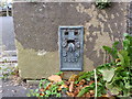
Ordnance Survey Flush Bracket G661
This bracket can be found on the wall of a private dwelling in Causwayhead Road, Stirling. The benchmark height is recorded as being 9.502 metres above seal level. For more detail see : http://www.bench-marks.org.uk/bm20331
Image: © Peter Wood
Taken: 4 Oct 2017
0.10 miles
5
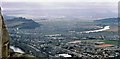
Stirling from the Wallace Monument
Stirling Castle is in the distance on the right and a train heads along the railway line in the bottom right. The Battle of Stirling Bridge was fought in the loop of the Forth on the right.
Image: © Mike Pennington
Taken: 4 May 2009
0.11 miles
6
Cleuch Road in Stirling
Looking north-westward.
Image: © Peter Wood
Taken: 4 Oct 2017
0.12 miles
7
View towards Stirling Castle
View from near the base of the National Wallace Monument over the meandering River Forth below towards Stirling Castle.
Image: © Gerald England
Taken: 22 Mar 2017
0.13 miles
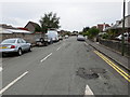
8
Causewayhead Road
The A9 leaving Stirling to the north.The view is dominated by the Wallace Monument.
Image: © Bill Boaden
Taken: 8 Aug 2013
0.14 miles
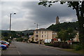
9
Causewayhead
On the north side of Stirling, with Stirling Castle in the distance.
Image: © Mike Pennington
Taken: 7 Jun 2007
0.15 miles
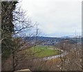
10
Meandering Forth
A meander in the River Forth at Stirling, with Stirling Castle to the right. Photographed from the Wallace Monument to the NE.
Image: © Mike Pennington
Taken: 10 Jun 2005
0.18 miles