IMAGES TAKEN NEAR TO
Causewayhead Road, STIRLING, FK9 5HL
Introduction
This page details the photographs taken nearby to Causewayhead Road, FK9 5HL by members of the Geograph project.
The Geograph project started in 2005 with the aim of publishing, organising and preserving representative images for every square kilometre of Great Britain, Ireland and the Isle of Man.

There are currently over 7.5m images from over14,400 individuals and you can help contribute to the project by visiting https://www.geograph.org.uk
Image Map
Images are licensed for reuse under creativecommons.org/licenses/by-sa/2.0
Notes
- Clicking on the map will re-center to the selected point.
- The higher the marker number, the further away the image location is from the centre of the postcode.
Image Listing (80 Images Found)
Images are licensed for reuse under creativecommons.org/licenses/by-sa/2.0
Image
Details
Distance
1
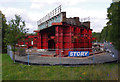
Causewayhead Road railway bridge replacement
The old steel girder bridge stands on temporary supports. It has been jacked up and moved about 200m using a pair of SPMTs (self-propelled modular transporters). Presumably, work is concentrated on installing the new bridge, before disposing of the old bridge.
Image: © Ian Taylor
Taken: 29 Sep 2013
0.05 miles
2
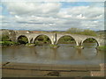
New Stirling Bridge
Road bridge, built in 1931, crossing the River Forth
Image: © Eirian Evans
Taken: 7 Sep 2021
0.05 miles
3
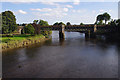
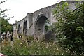
River Forth railway bridges
It's not immediately obvious that there are 2 parallel bridges here. The nearer upstream bridge carries the line from Stirling to Dunblane and Perth, which opened in 1848. The downstream bridge carries the line to Alloa, opened in 1852, closed in 1968 and re-opened in 2008. There are plans to electrify both of these lines.
Image: © Ian Taylor
Taken: 29 Sep 2013
0.06 miles
4
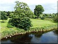
The River Forth
Looking downstream from the famous old bridge, with a Mute Swan family lying close to the far bank.
Image: © Mary and Angus Hogg
Taken: 15 Jul 2012
0.06 miles
5
Stirling, the A9 bridge
The town to the right and Causewayhead (the causeway the patriot army led by William Wallace attacked from in 1297); until the M9 Stirling by-pass was opened this used to be the main road to the north. The Forth is almost at high tide and in mild spate after a few days of heavy rain and at this time a treacherous stretch of water below the piers of the Auld Brig with strong eddies and whirlpools evident.
Image: © Robert Murray
Taken: 13 Aug 2011
0.06 miles
6
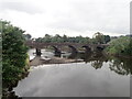
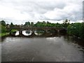
The Auld Brig of Stirling
Built about 1500, this thought to be the site of the battle in 1297.
Image: © Robert Murray
Taken: 24 Sep 2008
0.06 miles
7
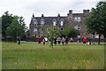
Drumming practice near Sirling Bridge
The pipers had also been part of the practice but had finished earlier and gone.
Image: © Bill Boaden
Taken: 8 Aug 2013
0.06 miles
8
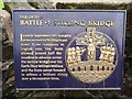
Stirling, the Auld Brig, battle plaque
Plaque to commemorate the battle of 1297 on plinth situated near the north portal of the auld brig of Stirling.
Image: © Robert Murray
Taken: 13 Aug 2011
0.07 miles
9
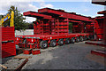
Causewayhead Road railway bridge replacement
A pair of SPMTs (self-propelled modular transporters), each with 14 axles, stand in the construction compound. They have been used to jack up and remove the old bridge, and then manoeuvre the new bridge into position.
Image: © Ian Taylor
Taken: 29 Sep 2013
0.07 miles