IMAGES TAKEN NEAR TO
Blairdrummond, STIRLING, FK9 4UX
Introduction
This page details the photographs taken nearby to FK9 4UX by members of the Geograph project.
The Geograph project started in 2005 with the aim of publishing, organising and preserving representative images for every square kilometre of Great Britain, Ireland and the Isle of Man.

There are currently over 7.5m images from over14,400 individuals and you can help contribute to the project by visiting https://www.geograph.org.uk
Image Map (Loading...)


Getting Data...Please wait
Leaflet Map data © OpenStreetMap
Images are licensed for reuse under creativecommons.org/licenses/by-sa/2.0
Notes
- Clicking on the map will re-center to the selected point.
- The higher the marker number, the further away the image location is from the centre of the postcode.
Image Listing (32 Images Found)
Images are licensed for reuse under creativecommons.org/licenses/by-sa/2.0
Image
Details
Distance
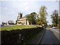
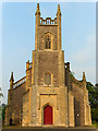
3
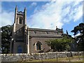
Kincardine in Mentieth Church of Scotland
Image: © Bill Henderson
Taken: 28 Jul 2016
0.03 miles
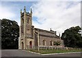
4
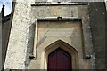
Church of Kincardine in Menteith - Inscription on tower
Image: © John Salmon
Taken: 11 Aug 2008
0.04 miles
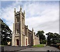
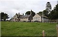
6
The church, Kincardine-in-Menteith
Church of Scotland church.
Image: © Andrew Smith
Taken: 9 Jun 2006
0.05 miles
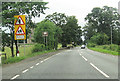
7
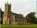
The church, Kincardine-in-Menteith
The church is just off the A84. Its stands apart from its graveyard, which is to the south and on the other side of the road.
Image: © Andrew Smith
Taken: 9 Jun 2006
0.05 miles