IMAGES TAKEN NEAR TO
Drip Bridge, STIRLING, FK9 4UF
Introduction
This page details the photographs taken nearby to FK9 4UF by members of the Geograph project.
The Geograph project started in 2005 with the aim of publishing, organising and preserving representative images for every square kilometre of Great Britain, Ireland and the Isle of Man.

There are currently over 7.5m images from over14,400 individuals and you can help contribute to the project by visiting https://www.geograph.org.uk
Image Map (Loading...)


Getting Data...Please wait
Leaflet Map data © OpenStreetMap
Images are licensed for reuse under creativecommons.org/licenses/by-sa/2.0
Notes
- Clicking on the map will re-center to the selected point.
- The higher the marker number, the further away the image location is from the centre of the postcode.
Image Listing (22 Images Found)
Images are licensed for reuse under creativecommons.org/licenses/by-sa/2.0
Image
Details
Distance
1
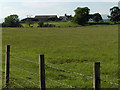
Hill of Drip
The farm stands on a slight rising to the east of Drip Moss, an area of flat mixed pastoral and arable farmland.
Image: © Andrew Smith
Taken: 8 Jun 2006
0.03 miles
2
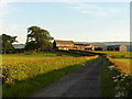
Hill of Drip
From its entrance on the A84.
Image: © Andrew Smith
Taken: 8 Jun 2006
0.03 miles
3

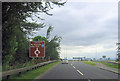
Stirling sunset
A view from the A84 (Chalmerston Road junction) of Stuc a' Chroin (Image) and Ben Vorlich (Image). These are the nearest munros to Stirling. The fields in the foreground are currently subject to a planning application for a large livestock market and retail park. This seems the wrong place for such a development to me, see www.blairdrummond.info/bam
Image: © Andrew Smith
Taken: 27 Jun 2006
0.11 miles
5
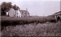
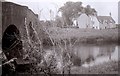
Old Inn Cottage and bridge
Old Inn Cottage is a former 18th century inn and is Category C listed. It sits beside a crossing point over the River Forth, just west of Stirling. The old 18th century bridge Image just out of view to the left has been replaced by the newer bridge on the right which carries the A84 over the river.
Image: © Richard Sutcliffe
Taken: Unknown
0.19 miles
6
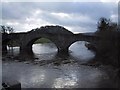
Old Drip Bridge and former inn
Built by public subscription, about 1773, the Category A listed bridge http://portal.historicenvironment.scot/designation/LB6725 crosses the River Forth just to the west of Stirling. Old Inn Cottage is a former 18th century inn and is Category C listed.
Scanned from a black and white negative.
Image: © Richard Sutcliffe
Taken: Unknown
0.20 miles
7
Old Bridge over the River Forth
This bridge has been replaced by the modern A82 road bridge. Craigforth Image can be seen beyond the bridge.
Image: © Sarah Charlesworth
Taken: 3 Dec 2000
0.21 miles
8
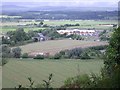
Garden Centre
The new garden centre on the A84 just outside Stirling, taken from Craigforth Crag, just outside the square. The old road bridge over the forth can also be seen.
Image: © Callum Black
Taken: 3 Jul 2005
0.22 miles
9
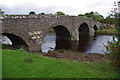
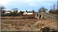
Drip Bridge
Old road bridge over the River Forth. See Image for more information.
Image: © Ian Taylor
Taken: 5 Oct 2013
0.22 miles
10
Old Bridge, Drip
The old bridge, now replaced by a modern one, shortly before the Forth joins the Teith.
Image: © Richard Webb
Taken: 13 Feb 2010
0.22 miles