IMAGES TAKEN NEAR TO
The Castle Business Park, STIRLING, FK9 4TS
Introduction
This page details the photographs taken nearby to The Castle Business Park, FK9 4TS by members of the Geograph project.
The Geograph project started in 2005 with the aim of publishing, organising and preserving representative images for every square kilometre of Great Britain, Ireland and the Isle of Man.

There are currently over 7.5m images from over14,400 individuals and you can help contribute to the project by visiting https://www.geograph.org.uk
Image Map
Images are licensed for reuse under creativecommons.org/licenses/by-sa/2.0
Notes
- Clicking on the map will re-center to the selected point.
- The higher the marker number, the further away the image location is from the centre of the postcode.
Image Listing (8 Images Found)
Images are licensed for reuse under creativecommons.org/licenses/by-sa/2.0
Image
Details
Distance
1
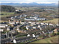
Raploch, and Castle Business Park
Looking over the housing estate, up the Forth Valley towards Ben Ledi, in the centre distance, 27km away.
Image: © M J Richardson
Taken: 23 Feb 2016
0.16 miles
3
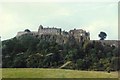
Stirling Castle
Stirling's history has been bloody and the castle on its crag is a stern redoubt. It stood in for Colditz in a 1970s TV series. The castle itself straddles two squares but is seen here from this square, looking east towards the crags.
Image: © Rosalind Mitchell
Taken: Unknown
0.20 miles
4
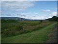
Stirling, wetland
At the park & ride area near Craigforth.
Image: © Robert Murray
Taken: 6 Oct 2011
0.21 miles
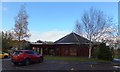
5
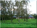
Stirling, River House restaurant
View through wooded gardens in the extreme north west corner of this square.
Image: © Robert Murray
Taken: 18 Sep 2011
0.23 miles
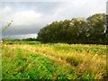
6
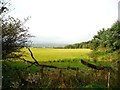
Stirling, carse near Craigforth
View across the carse to North Kerbonny.
Image: © Robert Murray
Taken: 6 Oct 2011
0.23 miles
8
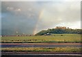
Rainbow from the M9
A view from near what was then the end of the M9 looking across the carriageway towards a rainbow between the Wallace Monument in Image and Stirling Castle in Image The time was 8.15 p.m.
Image: © Gerald England
Taken: 2 Aug 1985
0.24 miles