IMAGES TAKEN NEAR TO
Pendreich Road, STIRLING, FK9 4LY
Introduction
This page details the photographs taken nearby to Pendreich Road, FK9 4LY by members of the Geograph project.
The Geograph project started in 2005 with the aim of publishing, organising and preserving representative images for every square kilometre of Great Britain, Ireland and the Isle of Man.

There are currently over 7.5m images from over14,400 individuals and you can help contribute to the project by visiting https://www.geograph.org.uk
Image Map
Images are licensed for reuse under creativecommons.org/licenses/by-sa/2.0
Notes
- Clicking on the map will re-center to the selected point.
- The higher the marker number, the further away the image location is from the centre of the postcode.
Image Listing (6 Images Found)
Images are licensed for reuse under creativecommons.org/licenses/by-sa/2.0
Image
Details
Distance
1
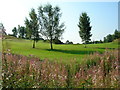
Bridge of Allan Golf Club Sunnylaw
9th hole at Bridge of Allan Golf Club.
Image: © David Philp
Taken: 4 Sep 2005
0.16 miles
2
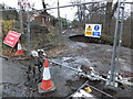
Landslip, Glen Road
Glen Road in Bridge of Allan has been undercut by a land slip leaving the road impassable.
Image: © Alpin Stewart
Taken: 31 Dec 2013
0.17 miles
3
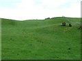
Grassland, Sunnylaw
Rolling grassland above the Allan Water.
Image: © Richard Webb
Taken: 14 May 2011
0.18 miles
4
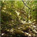
Cock's Burn
The Darn walk crosses a ravine. The bridge on the map went in 2012, so there is a bit of boulder hopping needed down here.
Image: © Richard Webb
Taken: 5 Jun 2018
0.23 miles
5
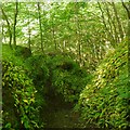
Descent to the Cock's Burn
On the Darn Walk where a steep holloway drops to a ravine crossing. The bridge has gone now, and there is some boulder hopping waiting below.
Image: © Richard Webb
Taken: 5 Jun 2018
0.23 miles
6
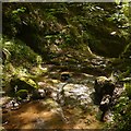
Cock's Burn
A downstream view from the site of the bridge on the Darn Walk. This is a deep rocky slot giving some excitement to the walk.
Image: © Richard Webb
Taken: 5 Jun 2018
0.25 miles