IMAGES TAKEN NEAR TO
Roughburn Road, STIRLING, FK9 4BL
Introduction
This page details the photographs taken nearby to Roughburn Road, FK9 4BL by members of the Geograph project.
The Geograph project started in 2005 with the aim of publishing, organising and preserving representative images for every square kilometre of Great Britain, Ireland and the Isle of Man.

There are currently over 7.5m images from over14,400 individuals and you can help contribute to the project by visiting https://www.geograph.org.uk
Image Map
Images are licensed for reuse under creativecommons.org/licenses/by-sa/2.0
Notes
- Clicking on the map will re-center to the selected point.
- The higher the marker number, the further away the image location is from the centre of the postcode.
Image Listing (6 Images Found)
Images are licensed for reuse under creativecommons.org/licenses/by-sa/2.0
Image
Details
Distance
1
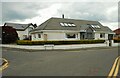
House on Forglen Road
At the corner of Forglen Crescent. Decorations in the window are for the Queen's Platinum Jubilee.
Image: © Richard Sutcliffe
Taken: 2 Jun 2022
0.03 miles
2
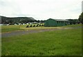
Pavilion, Strathallan Games Park
The site is home to the annual Bridge of Allan Highland Games.
Image: © Richard Sutcliffe
Taken: 2 Jun 2022
0.10 miles
4
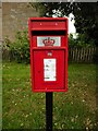
Postbox, Forglen Road
A pedestal postbox, which replaced a George V wall box mounted in a brick pillar, sometime between 2014 and 2016. It is postbox number FK9 201.
Image: © Richard Sutcliffe
Taken: 2 Jun 2022
0.18 miles
5
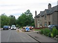
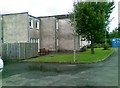
Bridge of Allan
A residential area of Bridge of Allan, just off the road to Cornton and Stirling.
Image: © Richard Webb
Taken: 9 Jul 2005
0.24 miles
6
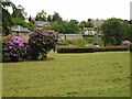
Pullar Memorial Park
Looking towards the war memorial, unveiled in 1923 in what was then a field, but which has subsequently been landscaped as a park, named after the donor of the ground, Mr Edmund Pullar of Westerton.
Image: © Richard Sutcliffe
Taken: 2 Jun 2022
0.24 miles