IMAGES TAKEN NEAR TO
Aberfoyle, STIRLING, FK8 3XH
Introduction
This page details the photographs taken nearby to FK8 3XH by members of the Geograph project.
The Geograph project started in 2005 with the aim of publishing, organising and preserving representative images for every square kilometre of Great Britain, Ireland and the Isle of Man.

There are currently over 7.5m images from over14,400 individuals and you can help contribute to the project by visiting https://www.geograph.org.uk
Image Map
Images are licensed for reuse under creativecommons.org/licenses/by-sa/2.0
Notes
- Clicking on the map will re-center to the selected point.
- The higher the marker number, the further away the image location is from the centre of the postcode.
Image Listing (7 Images Found)
Images are licensed for reuse under creativecommons.org/licenses/by-sa/2.0
Image
Details
Distance
1
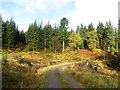
Road by Clashmore
The road passes through a large clearing around a house.
Image: © Richard Webb
Taken: 9 Nov 2013
0.06 miles
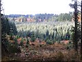
2
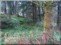
Loch Ard Forest
Typical Loch Ard terrain from the time the forest was widely used for orienteering in the 1980s and 90s. Since then the big conifer blocks have mostly been felled and replanted and there is rather less open commercial forest. The expansion of native woodland in Loch Ard suggests that this will continue to be a top class competition area in the future. Some of the forest, near Aberfoyle was used recently.
Loch Ard was nicknamed Loch Hard, and the two times that I ran here around 1980 were two of the toughest events that I have ever attended. (The Drumore Wood one was also one of my most enjoyable).
Image: © Richard Webb
Taken: 9 Nov 2013
0.12 miles
3
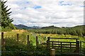
Open ground at Clashmore
Unplanted area near the house at Clashmore, Loch Ard Forest.
Image: © Jim Barton
Taken: 1 Sep 2015
0.15 miles
4
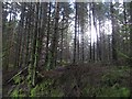
Sitka block, Loch Ard Forest
Near Clashmore.
Image: © Richard Webb
Taken: 9 Nov 2013
0.17 miles
5
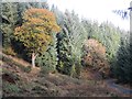
Loch Ard Forest
The oak is a remnant from the days when there were scattered trees and small woods occupying the mainly open land around the Duchray Water. The older trees are still there amongst the conifers.
Image: © Richard Webb
Taken: 9 Nov 2013
0.18 miles
7
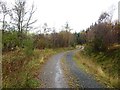
Road to Clashmore
Older maps show this as the only road to Clashmore. There are now a couple of logging roads that meet there as well as this road.
Image: © Richard Webb
Taken: 9 Nov 2013
0.21 miles