IMAGES TAKEN NEAR TO
Main Road, STIRLING, FK8 3UR
Introduction
This page details the photographs taken nearby to Main Road, FK8 3UR by members of the Geograph project.
The Geograph project started in 2005 with the aim of publishing, organising and preserving representative images for every square kilometre of Great Britain, Ireland and the Isle of Man.

There are currently over 7.5m images from over14,400 individuals and you can help contribute to the project by visiting https://www.geograph.org.uk
Image Map
Images are licensed for reuse under creativecommons.org/licenses/by-sa/2.0
Notes
- Clicking on the map will re-center to the selected point.
- The higher the marker number, the further away the image location is from the centre of the postcode.
Image Listing (56 Images Found)
Images are licensed for reuse under creativecommons.org/licenses/by-sa/2.0
Image
Details
Distance
1

Aberfoyle
Queen's Crescent. Houses probably former forestry stock. Achray Forest beyond.
Image: © Richard Webb
Taken: 28 Jul 2006
0.03 miles
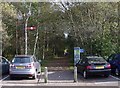
2

Open Space
At Aberfoyle. With the A821 behind.
Image: © Mick Garratt
Taken: 6 May 2011
0.04 miles
3
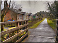
Walkway at Aberfoyle
The railway came across the soft moss of Central Scotland to Aberfoyle in 1882 but the line closed under the Beeching cuts and the Station was demolished in 1959. The line has been turned into a path for walkers and the station site is part of a large car park
Image: © Tom Sargent
Taken: 16 Oct 2009
0.05 miles
4

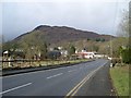
Car park, Queen's Crescent
And a fine view to the imposing Craigmore.
Image: © Stephen Sweeney
Taken: 15 Feb 2010
0.06 miles
5
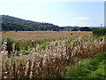
Wildlife Circuit near Aberfoyle
Just west of the Sustrans route is a wildlife circuit in an area bounded on three sides by the River Forth and Allt a Mhangan
Image: © Eirian Evans
Taken: 8 Sep 2021
0.08 miles
6
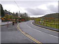
Main Street, Aberfoyle
The A821 (Main Street), leaving Aberfoyle.
Image: © David Dixon
Taken: 17 Apr 2012
0.08 miles
7
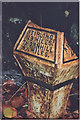
Old Milepost by the A821, Main Street, Balanton, Aberfoyle parish
Stirling GM casting by the A821, in parish of Aberfoyle (Stirling District), Aberfoyle Health Centre, near Balanton, against wall. Broken.
Inscription reads:-
: STIRLING / 19 MILES. / THORNHILL / 9¼ MILES : : AB(ERFOYLE) / (¼) / M(ILE) :
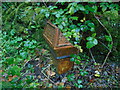
Surveyed
Milestone Society National ID: ST_STAF19
Image: © Milestone Society
Taken: Unknown
0.09 miles
8
Old milepost
The 19 miles from Stirling post still survives in spite of its broken state. It is on the north side of the road near to Aberfoyle Health Centre on the western approach into Aberfoyle and the lost legend was ABERFOYLE/ ½ MS.
Image: © Chris Minto
Taken: 17 Oct 2021
0.09 miles
9
Cyclepath to Gartmore
The path follows the line of the old railway line to Glasgow (presumably lost in the 1960s - the station was pulled down in 1959). To the left is a line of former railway cottages. The viewpoint is the wooden footbridge over Allt a'Mhangam.
Image: © David Dixon
Taken: 17 Apr 2012
0.09 miles
10
Aberfoyle and Craigmore
The northwestern view from the A81 at Queens Crescent.
Image: © Stephen Sweeney
Taken: 15 Feb 2010
0.11 miles