IMAGES TAKEN NEAR TO
Main Street, STIRLING, FK8 3UN
Introduction
This page details the photographs taken nearby to Main Street, FK8 3UN by members of the Geograph project.
The Geograph project started in 2005 with the aim of publishing, organising and preserving representative images for every square kilometre of Great Britain, Ireland and the Isle of Man.

There are currently over 7.5m images from over14,400 individuals and you can help contribute to the project by visiting https://www.geograph.org.uk
Image Map
Images are licensed for reuse under creativecommons.org/licenses/by-sa/2.0
Notes
- Clicking on the map will re-center to the selected point.
- The higher the marker number, the further away the image location is from the centre of the postcode.
Image Listing (105 Images Found)
Images are licensed for reuse under creativecommons.org/licenses/by-sa/2.0
Image
Details
Distance
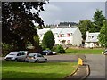
1
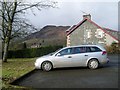
Car park, Queen's Crescent
And a fine view to the imposing Craigmore.
Image: © Stephen Sweeney
Taken: 15 Feb 2010
0.01 miles
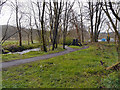
2
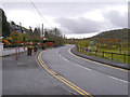
Main Street, Aberfoyle
The A821 (Main Street), leaving Aberfoyle.
Image: © David Dixon
Taken: 17 Apr 2012
0.02 miles
3
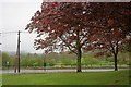
Open Space
At Aberfoyle. With the A821 behind.
Image: © Mick Garratt
Taken: 6 May 2011
0.03 miles
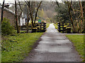
4
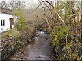
Allt a'Mhangam
Looking upstream from Aberfoyle Main Street.
Image: © David Dixon
Taken: 17 Apr 2012
0.05 miles
5
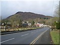
Aberfoyle and Craigmore
The northwestern view from the A81 at Queens Crescent.
Image: © Stephen Sweeney
Taken: 15 Feb 2010
0.06 miles
6
Aberfoyle
Queen's Crescent. Houses probably former forestry stock. Achray Forest beyond.
Image: © Richard Webb
Taken: 28 Jul 2006
0.06 miles
7
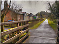
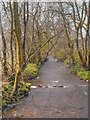
Cyclepath to Gartmore
The path follows the line of the old railway line to Glasgow (presumably lost in the 1960s - the station was pulled down in 1959). To the left is a line of former railway cottages. The viewpoint is the wooden footbridge over Allt a'Mhangam.
Image: © David Dixon
Taken: 17 Apr 2012
0.07 miles
8
Cycletrack and Bridge over Allt a'Mhangam
Image: © David Dixon
Taken: 17 Apr 2012
0.08 miles
9
Path Alongside Allt a'Mhangam
This site was once part of the former station which was pulled down in 1959. The remains of the old railway turntable used to turn the engines back to Glasgow can be seen amongst the trees.
Image: © David Dixon
Taken: 17 Apr 2012
0.09 miles
10
Allt a'Mhangam
Looking downstream, from the wooden footbridge, as Allt a'Mhangam flows towards the River Forth.
Image: © David Dixon
Taken: 17 Apr 2012
0.10 miles