
IMAGES TAKEN NEAR TO
Lochard Road, STIRLING, FK8 3TD
Introduction
This page details the photographs taken nearby to Lochard Road, FK8 3TD by members of the Geograph project.
The Geograph project started in 2005 with the aim of publishing, organising and preserving representative images for every square kilometre of Great Britain, Ireland and the Isle of Man.

There are currently over 7.5m images from over14,400 individuals and you can help contribute to the project by visiting https://www.geograph.org.uk
Image Map
Images are licensed for reuse under creativecommons.org/licenses/by-sa/2.0
Notes
- Clicking on the map will re-center to the selected point.
- The higher the marker number, the further away the image location is from the centre of the postcode.
Image Listing (6 Images Found)
Images are licensed for reuse under creativecommons.org/licenses/by-sa/2.0
Image
Details
Distance
1
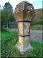
Old milepost
The now very rusty first milepost out of Aberfoyle on the road to Stronachlachar at Milton. In 2009 it was well-painted having been repainted by National Park volunteers. It was cast at the Grangemouth Ironworks.
Image: © Chris Minto
Taken: 15 Oct 2021
0.09 miles
2
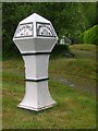
Old Milepost by the B829, Milton, Aberfoyle Parish
Stirling GM casting by the B829, in parish of Aberfoyle (Trossachs District), Milton, 1 mile West of junction with the A821, entrance to Holm House.
Surveyed
Milestone Society National ID: ST_AFSR01
Image: © Milestone Society
Taken: 1 Jan 2009
0.09 miles
4
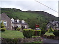
Milton
Hillside to the north of Milton
Image: © Angela Mudge
Taken: 11 Jul 2006
0.15 miles
5
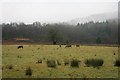
Deer near Aberfoyle
Deer in the mist near Aberfoyle.
Image: © Mark Trott
Taken: 14 Jan 2009
0.16 miles
6
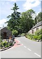
Milton
The B829 heading west through Milton, near Aberfoyle.
Image: © James T M Towill
Taken: 25 Jul 2018
0.17 miles