IMAGES TAKEN NEAR TO
Thornhill, STIRLING, FK8 3QQ
Introduction
This page details the photographs taken nearby to FK8 3QQ by members of the Geograph project.
The Geograph project started in 2005 with the aim of publishing, organising and preserving representative images for every square kilometre of Great Britain, Ireland and the Isle of Man.

There are currently over 7.5m images from over14,400 individuals and you can help contribute to the project by visiting https://www.geograph.org.uk
Image Map
Images are licensed for reuse under creativecommons.org/licenses/by-sa/2.0
Notes
- Clicking on the map will re-center to the selected point.
- The higher the marker number, the further away the image location is from the centre of the postcode.
Image Listing (4 Images Found)
Images are licensed for reuse under creativecommons.org/licenses/by-sa/2.0
Image
Details
Distance
1
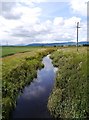
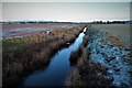
Goodie Water
Looking upstream from Netherton Bridge, south of Thornhill village.
Image: © James T M Towill
Taken: 29 Jul 2015
0.16 miles
2
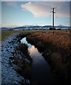
Goodie Water from Netherton Bridge
The setting winter sun catches Ben Ledi's snowcap.
Image: © Alan Reid
Taken: 22 Jan 2019
0.17 miles
4
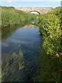
Netherton Bridge
Underwater vegetation in Goodie Water.
Image: © Andrew Smith
Taken: 25 Jun 2006
0.21 miles