IMAGES TAKEN NEAR TO
Thornhill, STIRLING, FK8 3QH
Introduction
This page details the photographs taken nearby to FK8 3QH by members of the Geograph project.
The Geograph project started in 2005 with the aim of publishing, organising and preserving representative images for every square kilometre of Great Britain, Ireland and the Isle of Man.

There are currently over 7.5m images from over14,400 individuals and you can help contribute to the project by visiting https://www.geograph.org.uk
Image Map
Images are licensed for reuse under creativecommons.org/licenses/by-sa/2.0
Notes
- Clicking on the map will re-center to the selected point.
- The higher the marker number, the further away the image location is from the centre of the postcode.
Image Listing (6 Images Found)
Images are licensed for reuse under creativecommons.org/licenses/by-sa/2.0
Image
Details
Distance
1
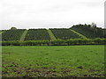
Christmas tree plantation
Near to the farm of the Brae of Boquhapple.
Image: © M J Richardson
Taken: 5 May 2014
0.08 miles
2
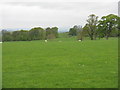
Pasture at Ballochneck
Looking across the fields near Thornhill.
Image: © M J Richardson
Taken: 5 May 2014
0.14 miles
3
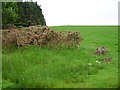
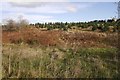
Declining fertility
The land beteween the Forth and Teith is not the best. Rising north from Thornhill, moorland and forestry soon take over. Here some not too healthy whins cling to the edge of the last improved field before the trees.
Image: © Richard Webb
Taken: 28 Jul 2006
0.15 miles
4
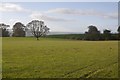
Another big grassy field
A parkland like field near Braendam House near Thornhill, Perthshire.
Image: © Richard Webb
Taken: 29 Oct 2017
0.18 miles
5
Christmas tree plantation, Boquhapple
Former fields, now growing Christmas trees.
Young trees show up in 2009 Streetview imagery.
Image: © Richard Webb
Taken: 29 Oct 2017
0.23 miles
6
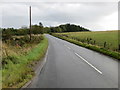
Road (B822) near Boquhapple Wood
Looking south-eastward.
Image: © Peter Wood
Taken: 2 Oct 2017
0.24 miles