IMAGES TAKEN NEAR TO
The Glebe, STIRLING, FK8 3PF
Introduction
This page details the photographs taken nearby to The Glebe, FK8 3PF by members of the Geograph project.
The Geograph project started in 2005 with the aim of publishing, organising and preserving representative images for every square kilometre of Great Britain, Ireland and the Isle of Man.

There are currently over 7.5m images from over14,400 individuals and you can help contribute to the project by visiting https://www.geograph.org.uk
Image Map
Images are licensed for reuse under creativecommons.org/licenses/by-sa/2.0
Notes
- Clicking on the map will re-center to the selected point.
- The higher the marker number, the further away the image location is from the centre of the postcode.
Image Listing (16 Images Found)
Images are licensed for reuse under creativecommons.org/licenses/by-sa/2.0
Image
Details
Distance
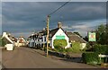
1
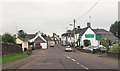
![Stirlingshire, Thornhill [2]](https://s2.geograph.org.uk/geophotos/02/93/63/2936366_00799c64_120x120.jpg)
Stirlingshire, Thornhill [2]
View west of the Main Street, pub on the right.
Image: © Robert Murray
Taken: 3 May 2012
0.05 miles
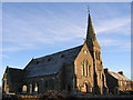
4
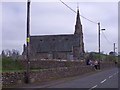
Norrieston Church, Thornhill
Viewed from the entrance to Mac(k)rieston on the A873.
Image: © Andrew Smith
Taken: 25 Jun 2006
0.06 miles
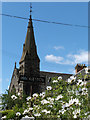
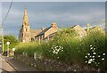
5
Stirling, Thornhill
Norrieston Church with cyclists resting at the gate. the spire is quite a landmark in the district.
Image: © Robert Murray
Taken: 3 May 2012
0.08 miles
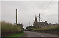
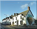
9
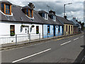
Cottages, Thornhill
On Main Street, the A873.
Image: © Andrew Smith
Taken: 25 Jun 2006
0.14 miles