IMAGES TAKEN NEAR TO
Glentirranmuir, STIRLING, FK8 3HU
Introduction
This page details the photographs taken nearby to Glentirranmuir, FK8 3HU by members of the Geograph project.
The Geograph project started in 2005 with the aim of publishing, organising and preserving representative images for every square kilometre of Great Britain, Ireland and the Isle of Man.

There are currently over 7.5m images from over14,400 individuals and you can help contribute to the project by visiting https://www.geograph.org.uk
Image Map
Images are licensed for reuse under creativecommons.org/licenses/by-sa/2.0
Notes
- Clicking on the map will re-center to the selected point.
- The higher the marker number, the further away the image location is from the centre of the postcode.
Image Listing (4 Images Found)
Images are licensed for reuse under creativecommons.org/licenses/by-sa/2.0
Image
Details
Distance
1
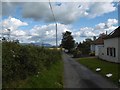
Glentirranmuir
The Military Road between Kippen and Gargunnock.
Image: © Richard Webb
Taken: 18 Sep 2015
0.10 miles
2
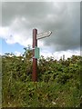
Path signpost
Kippen to Gargunnock on the Military Road.
Image: © Richard Webb
Taken: 18 Sep 2015
0.13 miles
3
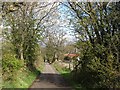
Old Military Road
Once the road between Dumbarton and Stirling, now a no through road lane.
Image: © Richard Webb
Taken: 17 Apr 2012
0.14 miles
4
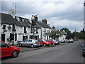
Cross Keys Hotel
A fine country pub since 1703 with simple fare and great ale.
Image: © JOHN MORELAND
Taken: 22 Jun 2005
0.23 miles