IMAGES TAKEN NEAR TO
Gargunnock, STIRLING, FK8 3BG
Introduction
This page details the photographs taken nearby to FK8 3BG by members of the Geograph project.
The Geograph project started in 2005 with the aim of publishing, organising and preserving representative images for every square kilometre of Great Britain, Ireland and the Isle of Man.

There are currently over 7.5m images from over14,400 individuals and you can help contribute to the project by visiting https://www.geograph.org.uk
Image Map
Images are licensed for reuse under creativecommons.org/licenses/by-sa/2.0
Notes
- Clicking on the map will re-center to the selected point.
- The higher the marker number, the further away the image location is from the centre of the postcode.
Image Listing (11 Images Found)
Images are licensed for reuse under creativecommons.org/licenses/by-sa/2.0
Image
Details
Distance
1
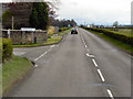
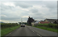
A811 Near Gungarrock
The A811, at the junction with the road to/from Gungarrock.
Image: © David Dixon
Taken: 18 Apr 2012
0.09 miles
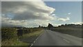
2
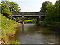
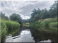
Gargunnock Bridge
The B8075 crosses the River Forth.
Image: © Andrew Smith
Taken: 10 Jun 2006
0.14 miles
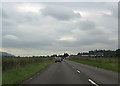
3
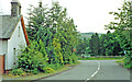
Site of Gargunnock station, 1997
View southward on B8075 approaching A811, where the ex-NBR Forth & Clyde line, Balloch (to right) - Stirling (to left) used to cross. The station was on the left here: it lost its passenger service on 1/10/34, but goods was handled (Stirling - Port of Menteith) until 5/10/59.
Image: © Ben Brooksbank
Taken: 1 Jul 1997
0.14 miles
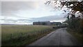
10
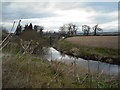
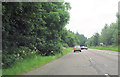
River Forth near Gargunnock bridge
Just downstream from the bridge.
Image: © Jim Smillie
Taken: 31 Mar 2009
0.20 miles