IMAGES TAKEN NEAR TO
Allan Park, STIRLING, FK8 2QE
Introduction
This page details the photographs taken nearby to Allan Park, FK8 2QE by members of the Geograph project.
The Geograph project started in 2005 with the aim of publishing, organising and preserving representative images for every square kilometre of Great Britain, Ireland and the Isle of Man.

There are currently over 7.5m images from over14,400 individuals and you can help contribute to the project by visiting https://www.geograph.org.uk
Image Map
Images are licensed for reuse under creativecommons.org/licenses/by-sa/2.0
Notes
- Clicking on the map will re-center to the selected point.
- The higher the marker number, the further away the image location is from the centre of the postcode.
Image Listing (320 Images Found)
Images are licensed for reuse under creativecommons.org/licenses/by-sa/2.0
Image
Details
Distance
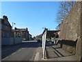
1
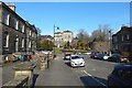
Allan Park, Stirling
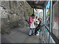
The street meets Dumbarton Road 50 metres ahead. For a view towards that junction from Dumbarton Road, see Image; the building beside the corner, with a green banner on front, can also be identified in that picture.
For the old wall that can be seen right of centre, see Image, showing the same part of it from Dumbarton Road.
Image: © Lairich Rig
Taken: 24 Feb 2018
0.02 miles
2
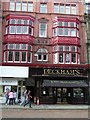
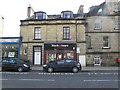
Peckham's, Stirling
A fine looking building
Image: © Kenneth Allen
Taken: 25 Sep 2006
0.03 miles
3
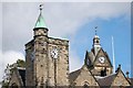
Two clocks
The clock on the left of the picture is on Allan Park South Church, the other clock belongs to Stirling Municipal Buildings.
Image: © Paul McIlroy
Taken: 12 Aug 2007
0.03 miles
4
Woodside B & B, Stirling
It is located at Back Walk
Image: © Kenneth Allen
Taken: 30 Apr 2010
0.03 miles
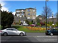
5
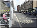
Waiting for the bus, Stirling
Pictured along Dumbarton Road
Image: © Kenneth Allen
Taken: 30 Apr 2010
0.03 miles
6
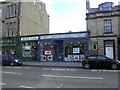
Health Foods / Framed Images Gallery, Stirling
They are located at Dumbarton Road
Image: © Kenneth Allen
Taken: 30 Apr 2010
0.03 miles
7
Black & Lizars, Stirling
It is located at Dumbarton Road
Image: © Kenneth Allen
Taken: 30 Apr 2010
0.03 miles
9

Dumbarton Road at Glebe Avenue
Glebe Avenue is on the right. Glebe is a Scottish word which means "a piece of land serving as part of a clergyman's benefice and providing income".
Image: © Thomas Nugent
Taken: 30 Dec 2016
0.04 miles
10
Old Town Wall beside Dumbarton Road
This is the opposite view to Image (in which the same bus stop is visible); see that item for further comments on the wall itself.
For the bus stop itself, see also Image For a view to the right from about the same place as the present picture, see Image
A road junction can be seen just past the large metal containers on the left; that is the junction with Image The building just beyond the junction can also be seen in that picture (note the green banner on the front), as can part of the Town Wall.
Image: © Lairich Rig
Taken: 24 Feb 2018
0.04 miles