IMAGES TAKEN NEAR TO
Newhouse, STIRLING, FK8 2AF
Introduction
This page details the photographs taken nearby to Newhouse, FK8 2AF by members of the Geograph project.
The Geograph project started in 2005 with the aim of publishing, organising and preserving representative images for every square kilometre of Great Britain, Ireland and the Isle of Man.

There are currently over 7.5m images from over14,400 individuals and you can help contribute to the project by visiting https://www.geograph.org.uk
Image Map
Images are licensed for reuse under creativecommons.org/licenses/by-sa/2.0
Notes
- Clicking on the map will re-center to the selected point.
- The higher the marker number, the further away the image location is from the centre of the postcode.
Image Listing (8 Images Found)
Images are licensed for reuse under creativecommons.org/licenses/by-sa/2.0
Image
Details
Distance

5

The High School, Stirling
No longer the High School site, they have moved nearby into a new building, but a building site.
Image: © Richard Webb
Taken: 20 Feb 2012
0.19 miles
6
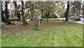
Randolph Stone, Stirling
One of two standing stones known locally as the Randolph Stones, supposedly marking the site of the first day of the battle of Bannockburn in 1314. However, recovered charcoal from the foundation cut of the stone was dated to 1283-1396, so there may be some basis to this!
Image: © Euan Nelson
Taken: 22 Oct 2019
0.20 miles
8
Weaver Row, St Ninians
View towards a rather busy supermarket.
Image: © Richard Webb
Taken: 14 Mar 2012
0.24 miles