IMAGES TAKEN NEAR TO
Woodside Road, STIRLING, FK8 1RF
Introduction
This page details the photographs taken nearby to Woodside Road, FK8 1RF by members of the Geograph project.
The Geograph project started in 2005 with the aim of publishing, organising and preserving representative images for every square kilometre of Great Britain, Ireland and the Isle of Man.

There are currently over 7.5m images from over14,400 individuals and you can help contribute to the project by visiting https://www.geograph.org.uk
Image Map
Images are licensed for reuse under creativecommons.org/licenses/by-sa/2.0
Notes
- Clicking on the map will re-center to the selected point.
- The higher the marker number, the further away the image location is from the centre of the postcode.
Image Listing (11 Images Found)
Images are licensed for reuse under creativecommons.org/licenses/by-sa/2.0
Image
Details
Distance

3
New housing at Raploch
Looking north from Stirling Castle. Forth Valley College is by the river at mid-left.
Image: © M J Richardson
Taken: 23 Feb 2016
0.15 miles
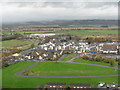
4
Glendevon Drive, Raploch
Looking towards the Community Campus with sports fields in use on the right. The weather was foul.
Image: © Richard Webb
Taken: 25 Oct 2008
0.17 miles
5
Drip Road
Raploch is now being redeveloped and there are a lot of new buildings here.
Image: © Richard Webb
Taken: 8 Mar 2012
0.17 miles
6
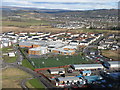
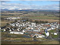
Raploch from Stirling Castle
Looking north to the Raploch Community Campus, sports field and housing estates.
Image: © M J Richardson
Taken: 23 Feb 2016
0.18 miles

8
Raploch from Stirling Castle
Looking up the valley of the River Forth from the Nether Bailey of Stirling Castle.
Image: © M J Richardson
Taken: 31 Oct 2011
0.20 miles
9
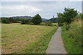
Path to Cornton
Because of the meandering river, you cannot avoid Cornton whichever way you go. The Wallace Monument is visible straight ahead.
Image: © Bill Boaden
Taken: 8 Aug 2013
0.20 miles
10
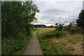
Path near the Forth
On the map, it looks like you might be walking next to the River Forth, but you cannot see it because of the undergrowth on the left.
Image: © Bill Boaden
Taken: 8 Aug 2013
0.21 miles