IMAGES TAKEN NEAR TO
FK8 1JF
Introduction
This page details the photographs taken nearby to FK8 1JF by members of the Geograph project.
The Geograph project started in 2005 with the aim of publishing, organising and preserving representative images for every square kilometre of Great Britain, Ireland and the Isle of Man.

There are currently over 7.5m images from over14,400 individuals and you can help contribute to the project by visiting https://www.geograph.org.uk
Image Map
Images are licensed for reuse under creativecommons.org/licenses/by-sa/2.0
Notes
- Clicking on the map will re-center to the selected point.
- The higher the marker number, the further away the image location is from the centre of the postcode.
Image Listing (75 Images Found)
Images are licensed for reuse under creativecommons.org/licenses/by-sa/2.0
Image
Details
Distance
1
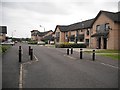
Cooperage Quay
New houses in Riverside on former industrial land.
Image: © Richard Webb
Taken: 18 Sep 2009
0.01 miles
5
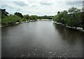
River Forth
Looking downstream from Cambuskenneth Bridge.
Image: © Richard Sutcliffe
Taken: 18 May 2022
0.04 miles
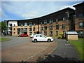
6
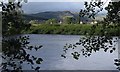
Riverside, Stirling
Looking across the Forth to Riverside and Dumyat
Image: © Donald MacDonald
Taken: 5 Jul 2020
0.10 miles
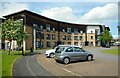
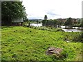
7

Abbey Road, Stirling
Stirling Castle is prominent on top of its hill in the distance.
Image: © Richard Sutcliffe
Taken: 18 May 2022
0.10 miles
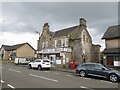
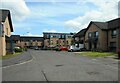
10
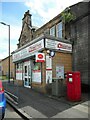
Riverside Mini-Market
Groceries, wine and spirits, stationery, newspapers and Post Office services. On Abbey Road.
Image: © Richard Sutcliffe
Taken: 18 May 2022
0.12 miles