
IMAGES TAKEN NEAR TO
Bow Street, STIRLING, FK8 1BS
Introduction
This page details the photographs taken nearby to Bow Street, FK8 1BS by members of the Geograph project.
The Geograph project started in 2005 with the aim of publishing, organising and preserving representative images for every square kilometre of Great Britain, Ireland and the Isle of Man.

There are currently over 7.5m images from over14,400 individuals and you can help contribute to the project by visiting https://www.geograph.org.uk
Image Map
Images are licensed for reuse under creativecommons.org/licenses/by-sa/2.0
Notes
- Clicking on the map will re-center to the selected point.
- The higher the marker number, the further away the image location is from the centre of the postcode.
Image Listing (573 Images Found)
Images are licensed for reuse under creativecommons.org/licenses/by-sa/2.0
Image
Details
Distance
1
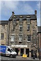
Darnley Coffee House, 18 Bow Street, Stirling
Category A listed building of late 16th or early 17th century renovated in 1957-8. The house was reputedly the nursery of James VI and of his son Prince Henry but this, like that which associates the house with Darnley, does not seem to be supported by much evidence, more probably the house should be associated with the Erskines of Gogar. Additionally the plaque outside states that Janet Kilbowie's Tavern was in this house where, in 1651, the town surrendered to Cromwell's General Monck.
Image: © Jo and Steve Turner
Taken: 17 Jun 2014
0.01 miles
2
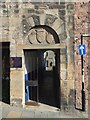
Erskine of Gogar's House: detail
The plaque calls it Darnley's House, but the tradition behind that name is not well supported; see https://canmore.org.uk/site/46204 at Canmore for details. For the whole building, see another contributor's earlier picture: Image
The carved details above the passageway can be seen to date from 1957, when the building was renovated.
Image: © Lairich Rig
Taken: 21 Sep 2019
0.01 miles
3
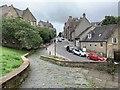
Bow Street, Stirling
From St John Street.
Image: © Andrew Abbott
Taken: 18 Aug 2020
0.01 miles
4
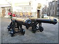
Cannon in Broad Street
Before Tommy Sheridan's Private Member's Bill brought about the abolition of warrant sales, I'll bet these gave the bailiffs some second thoughts before entering the 'top of the town'.
Image: © kim traynor
Taken: 27 Nov 2011
0.02 miles
5
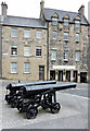
Broad Street cannons
At the corner of Broad Street and St Mary's Wynd.
Image: © Thomas Nugent
Taken: 20 Jun 2015
0.02 miles
6
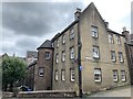
3 Bow Street, Stirling
Dated 1960. 2-storey, 4-bay and stair tower to right set against corner building (Nos 1 and 3 Broad Street, listed separately). Terraced tenement. Red sandstone rubble with ashlar margins. Eaves band, projecting cills.
Grade C listed. Listing number LB45378.
Image: © Andrew Abbott
Taken: 18 Aug 2020
0.02 miles
7
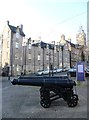
Halt! Who goes there?
...tourists visiting Stirling Castle, of which these cannon in Broad Street give a premonition. Perhaps even more startling than their presence here is the fact that they appear not to have suffered any vandalism.
Image: © kim traynor
Taken: 27 Nov 2011
0.03 miles
8
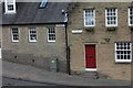
Hermon Evangelical Church, 2 Bow Street and 78 Baker Street, Stirling
Both Category C listed, Stirling Burgh Architect and Sir Frank Mears & Partners conceived the buildings as part of a wider municipal development in 1938 but they were not realised until about 1955.
Image: © Jo and Steve Turner
Taken: 17 Jun 2014
0.03 miles
9
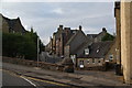
Roads on a gradient in Stirling
The whole of the south eastern side of the city centre is on a long slope which you notice when walking up to the castle.
Image: © Bill Boaden
Taken: 8 Aug 2013
0.04 miles
10
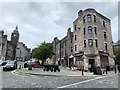
Broad Street, Stirling
From the junction with Bow Street.
Image: © Andrew Abbott
Taken: 18 Aug 2020
0.04 miles