IMAGES TAKEN NEAR TO
STIRLING, FK7 9QN
Introduction
This page details the photographs taken nearby to FK7 9QN by members of the Geograph project.
The Geograph project started in 2005 with the aim of publishing, organising and preserving representative images for every square kilometre of Great Britain, Ireland and the Isle of Man.

There are currently over 7.5m images from over14,400 individuals and you can help contribute to the project by visiting https://www.geograph.org.uk
Image Map
Images are licensed for reuse under creativecommons.org/licenses/by-sa/2.0
Notes
- Clicking on the map will re-center to the selected point.
- The higher the marker number, the further away the image location is from the centre of the postcode.
Image Listing (11 Images Found)
Images are licensed for reuse under creativecommons.org/licenses/by-sa/2.0
Image
Details
Distance
1
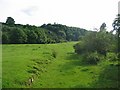
Old Track. Loch Coulter Burn
A sunken long disused trackway through farmland beside the Loch Coulter burn.
Image: © Richard Webb
Taken: 8 Jul 2005
0.09 miles
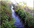
2
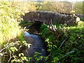
Milnholm, Weir
The Loch Coulter Burn comes through the bridge where it is met by a weir (on the left), the channel flowing towards the photographer in the foreground here is artificial, it is a lade which takes most of the burn's flow and diverts it to Howietoun Fishery (owned by Stirling University Aquaculture Dept.), after Howietoun takes its requirements what is left empties into the Sauchie Burn a few hundred metres downstream and thereafter to the Bannock Burn. What volume is left below the weir is named the Auchenbowie Burn and follows its natural course to the Carron at Denny where it is known as the Avon Burn.
Image: © Robert Murray
Taken: 21 May 2012
0.09 miles
3
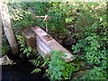
Milnholm, sluice
Controls the abstraction from the burn to the lade.
Image: © Robert Murray
Taken: 21 May 2012
0.09 miles
4
![Milnholm, Weir [2]](https://s3.geograph.org.uk/geophotos/02/95/50/2955003_49e809c9_120x120.jpg)
Milnholm, Weir [2]
View over the weir where the burn takes a name change from Loch Coulter to Auchenbowie.
Image: © Robert Murray
Taken: 21 May 2012
0.10 miles
5
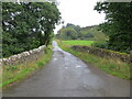
Minor road and bridge crossing a small burn near to Milnholm
Looking south-eastward.
Image: © Peter Wood
Taken: 3 Sep 2022
0.10 miles
6
Milnholm, lade
The channel that leads away from the Loch Coulter/Auchenbowie Burn at the Milnholm weir. It follows the eastern side of the minor road.
Image: © Robert Murray
Taken: 21 May 2012
0.10 miles
7
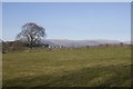
Field, Craigend
A view towards Ben Cleuch.
Image: © Richard Webb
Taken: 27 Mar 2017
0.14 miles

9
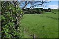
Field, Milnholm
The Loch Coulter Burn flows amongst the trees on the left.
Image: © Richard Webb
Taken: 31 May 2017
0.16 miles
10
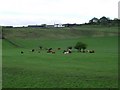
Lazy cows
Craigquarter Farm sits atop the ridge.
Image: © Robert Murray
Taken: 9 May 2010
0.19 miles